search posts

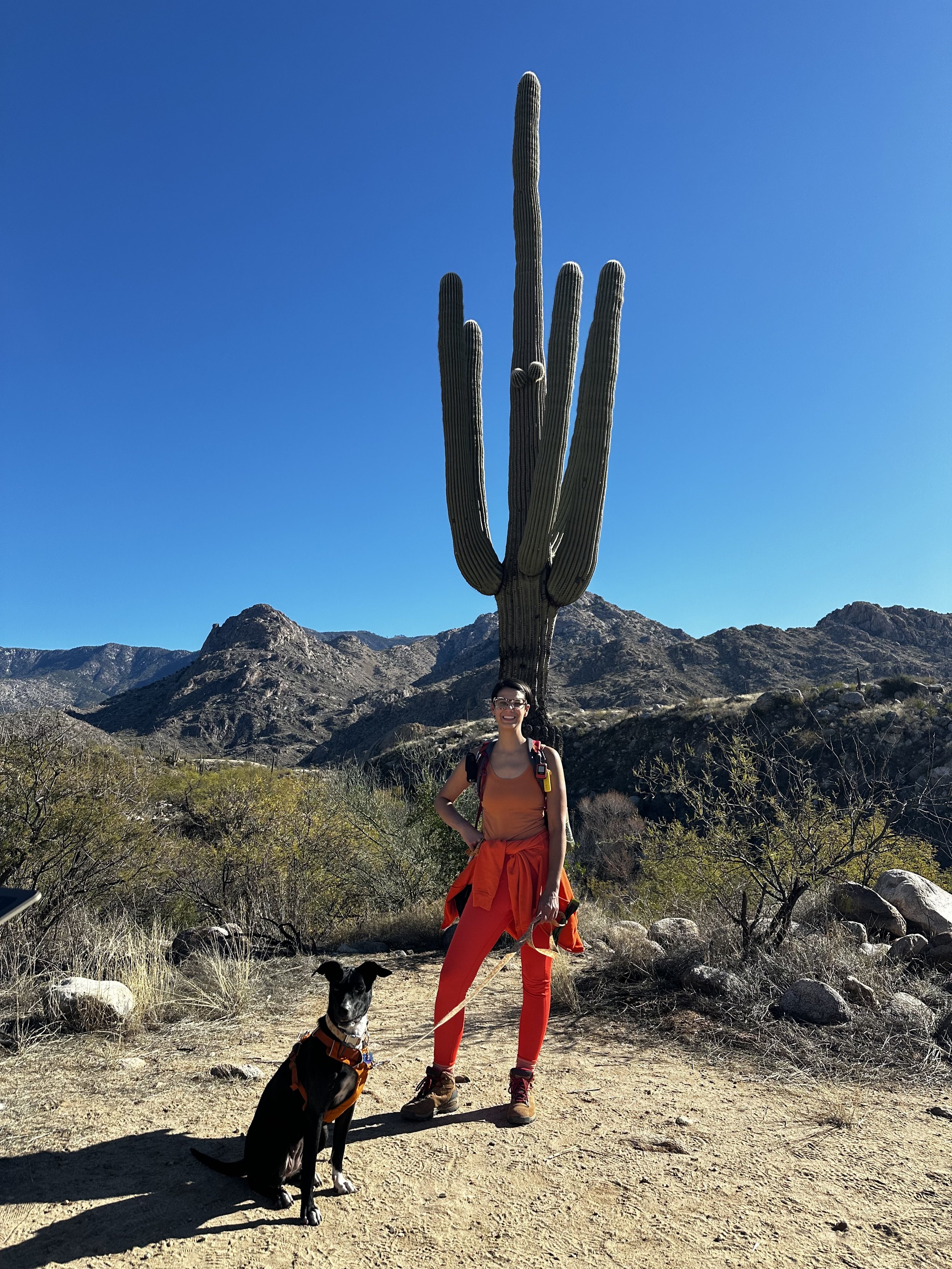
favorite dog-friendly hikes in tucson: where to hike with dogs in tucson
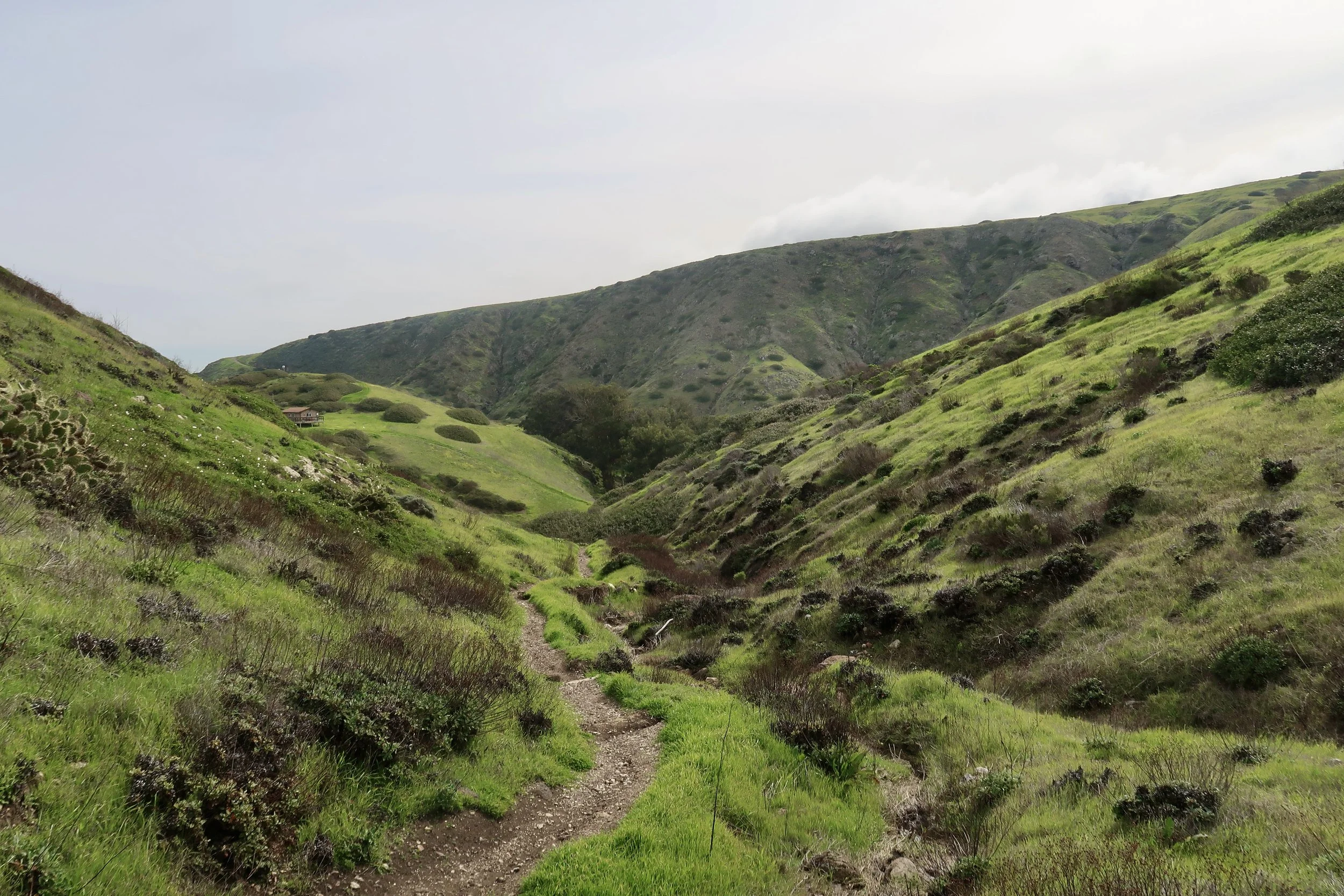
desert hiking areas for dogs

saguaros at sunset in tucson mountain park
this post includes affiliate links. any purchases made from affiliate links may provide me with a small amount of compensation. it will not affect the price of your purchase.
we first visited tucson last winter and knew immediately we wanted to return. (you can find our saguaro national park itinerary here and family friendly activities in tucson here) but this time around, we had our adventure pup in tow! i was honestly surprised at how dog-friendly tucson is; we had plenty of options for exploring this beautiful desert with bebe. here are a few of the dog-friendly hikes in tucson that we enjoyed!
what to bring when hiking with dogs in tucson
there are a few items we like to have on hand every time we go hiking with dogs. in addition to a leash and harness, here’s what to bring when hiking with dogs in tucson:
travel bowl: this bowl is very light and portable. I used the attached carabiner to hook it to my daypack and then fill it from my own water.
first aid kit: we carry a basic first aid kit on every hike, which already contains most of the essentials for dog first aid. the one addition we keep on hand is a wound care spray for pets. if you’re looking for a more complete dog first aid kit, this one looks like a great option.
poop bags: please pick up your dog poop (if you have the ability)! we buy these bags in bulk. this set comes with a dispenser if you need one. i also have this pup pouch for storing used bags so i don’t have to hold onto them while hiking. it clips into my pack and blocks and odor - it’s been so helpful to have!
tick removal tool: i bring this tick removal tool every time i travel with bebe. though she is protected from ticks via medication, it reduces the likelihood that ticks will get transported into our vehicle or home - and ultimately onto a person!
tuscan hikes with dogs: catalina state park
catalina state park has 8 trails, most of which are dog-friendly (there is one area of the park where dogs are not allowed due to bighorn sheep habitat). the scenery is beautiful and there is a mix of wide, natural surface trails and rockier terrain. this park is popular among dog families, so keep that in mind if your pup prefers more distance from other dogs. one other thing to note about the trails is that most are either relatively short (1 mile - ish) or relatively long (7+ miles).
in addition to hiking, catalina state park has quite of few other outdoor activities in tucson. the park has a campground and hosts a number of activities, concluding bird walks, nature programs, archeology talks, and even concerts! we went during one of the nature programs and got to learn about (and see up close!) many desert critters. kiddo even got to hold a tarantula!
hiking at catalina state park with bebe
dog-friendly hikes in tucson: madera canyon
part of coronado national forest, madera canyon is located about 25 miles from tucson. if you have a national park annual pass, you won’t need to pay to recreate here; otherwise, there is an $8 day fee. camping is also available. we parked at one of the campgrounds and it looked like an absolutely lovely spot for camping in arizona.
there are plenty of hiking options in the canyon, so be sure to check the hiking map in advance to make a plan. because this spot is higher elevation, there are more trees and the climate is a bit cooler than tucson - making it a great option for hiking with dogs in tucson. the terrain can be rocky and there are lots of deer, so be advised if your pup has a strong prey drive.

kiddo and bebe hiking in madera canyon
dog-friendly national parks: saguaro national park
while saguaro national park isn’t one of the most dog-friendly national parks, there are a couple short trail options for hiking with dogs. given that it’s right in tucson, i think it’s totally worth visiting saguaro national park with dogs. know in advance that neither trail offers poop bags, trash cans or water, so come prepared!
on the east side is the desert ecology trail. just over a quarter of a mile, this paved trail has lots of great interpretive information for getting acquainted with desert ecology. on the west side of saguaro national park, near the visit center is the desert discovery trail. this paved trail is a bit longer at half a mile and is absolutely gorgeous! of note - parking at the desert discovery trail, in particular, can be tricky. of the four times we visited over a year, we only got parking here once! be prepared to circle back a couple times.
check out this blog post which includes our itineraries for 2 days in saguaro national park and 1 day in saguaro national park. it’s worth noting the park has east and west sides, which are completely disconnected and about an hour’s drive apart. you could certainly visit both parks in a single day, but i’d recommend one day for each side so you can really enjoy and explore the unique ecosystems.
tucson is a very dog friendly destination with lots of options for dog-friendly trails. we highly recommend a visit and hope this list gives you some great ideas to go out wild and explore the beauty of tucson’s sonoran desert.
pin this post for later!

favorite itinerary: things to do in guadalupe mountains national park
top sites to see in this less frequented hidden gem

kiddo hiking to smith spring in guadalupe mountains national park
this post includes affiliate links. any purchases made from affiliate links may provide me with a small amount of compensation. it will not affect the price of your purchase.
guadalupe mountains national park was a big surprise for me. one of the least visited national parks, i found guadalupe mountains to be quite beautiful with very interesting geologic history.
guadalupe mountains national park is another of those parks that i wish we had the opportunity to spend more time in. there’s a lot to see and some really big hikes in guadalupe mountains that would be a thrill to complete - including climbing guadalupe peak, the highest natural point in the entire state of texas!
alas, the weather was not in our favor. with elevations between 3,000 and 8,000+ feet, there can be a lot of weather variation in the park. high winds are typical through the fall and winter and, ultimately, that’s what bested us. if you’re looking for the best time of year to visit, the weather in guadalupe mountains is more mild in spring and summer.
land of the mescalero apache
the land presently known as guadalupe mountains national park is the indigenous homeland of the mescalero apache. (the mescalero apache also inhabited the land that became white sands national park and carlsbad caverns national park.)
“traditionally, when a mescalero apache man married, he moved in with his wife’s family. while mescalero society did have gender roles, there was close collaboration between men and women. men helped women during agave roasts. women accompanied men on buffalo hunts.
women traditionally gathered and prepared food in mescalero apache society. to keep her family fed, a mescalero woman needed a deep understanding of the resources and cycles of her land. this knowledge of local plants meant that women sometimes held roles as healers. many of the great shamans in mescalero stories are women.”

what to bring to guadalupe mountains national park
layers: one of the biggest climate factors in the park is elevation. there are big shifts in the temperature throughout the park, based on where you are and what the elevation is. if you’re exploring multiple areas or doing one of the multiple hikes that climb in elevation, it’s best to be prepared with layers.
hiking poles & sturdy boots: it’s pretty rocky on the trails and areas can get muddy and slick, so a good idea to have both good hiking boots and a set of hiking poles. we’ve used these hiking poles in all conditions. kiddo currently wears these hiking boots. i have high arches and am always alternating between boots. my two favorite pairs these days are these and these.
sun protection: regardless of time of year or elevation, sun is abundant in guadalupe mountains.
sunscreen: this one is our favorite. it’s spf 50 and we like the mousse because it’s easy to apply, but you can also get the lotion or the mist.
water bottles: kiddo uses this camelpak on all our hikes. my current favorite water bottle is this one from wondery.
other sun protection: we recently purchased this buff for kiddo as a multi-use item. it protects his neck from sun but can also be worn in a myriad of ways, based on need. we most often use it as a headband! i wear a wide brim hat that i purchased from a park gift shop years ago, but similar styles can be found here and here.
a note about camping in guadalupe mountains national park
guadalupe mountains has three developed campgrounds open year round which are open to tent or vehicle camping, including the frijole horse corral campground for horse campers.
the pine springs campground is located near the visitor center and has basic amenities including pit toilets and utility sinks. the dog canyon campground is much more secluded and quite a distance from the visitor center. it does have restrooms as well as 4 designated spots for rv campers. there are no showers in the park.

guadalupe mountains national park itinerary
due to weather - extremely high winds - our trip to guadalupe mountains national park was cut short. be prepared for shifting weather conditions no matter the time of year. we ended up postponing for three days until we couldn’t any longer. it meant we missed out on some of the big hikes we had planned, but we did enjoy a sunny (albeit it briskly chilly!) morning in the park. below is our itinerary for one day in guadalupe mountains national park.
i’ve also included a few other things i wish we had time for. something to consider if you have two days in guadalupe mountains national park or more!
one day in guadalupe mountains national park
visitor center: make sure to start your day at one of the park’s two visitor centers to check the latest conditions. again, conditions can shift quickly and vary throughout the park, so you’ll want to latest information on the trails you’re planning to visit.
hike devil’s hall: this strenuous, 4.2 mile hike takes visitors through a natural staircase between steep canyon walls. there is an incredible amount of scrambling, as well as a lot of loose rocks and debris. make sure you have plenty of time, water and snacks to tackle this incredible hike!
visit frijole ranch: after your big trek, head over to frijole ranch for a picnic lunch. while there, check out the frijole ranch history museum, which gives a great overview of the human history of the park. even if the museum is closed, you can walk the grounds and peek into the one-room school house to imagine what life was like here 150 years ago.
hike smith and manzanita springs: just beyond the frijole ranch history museum is the trailhead for the smith spring loop that also takes you to manzanita spring. the 2.3 mile hike has beautiful scenery and gives a good sense for the ecology of the park. the springs are quite different and both are fascinating and lovely in their own ways. i would consider this trail a *do not miss for this park!

if you have more time in guadalupe mountains national park
here’s a list of places we wish we could have visited if we had more time in the park.
hike guadalupe peak - this day trek up the to the highest natural point in texas is a bucket list item for us!
visit one of the many viewpoints - there’s a lot to see in this park, including several peaks that each have their own viewpoints. of note - guadalupe mountains have their own el capitan! learn more about the viewpoint here.
take a scenic drive to dog canyon - this part of the park is more remote and the one-way drive through the chihuahuan desert takes 2 hours. you could start your morning with a hike in pine springs and then spend the afternoon exploring dog canyon.
visit the salt basin dunes - this area of the park is unfrequented, but gives the opportunity to climb white gypsum sand dunes with incredible views of both the guadalupe mountains and el capitan. if you have an extra day to explore, this would make a memorable adventure!
i hope this guide to guadalupe mountains national park inspires you to go out wild and visit this hidden gem tucked away in the far west corner of texas. there are so many surprises to uncover!

favorite itinerary: visiting carlsbad caverns national park
one day itinerary for carlsbad caverns
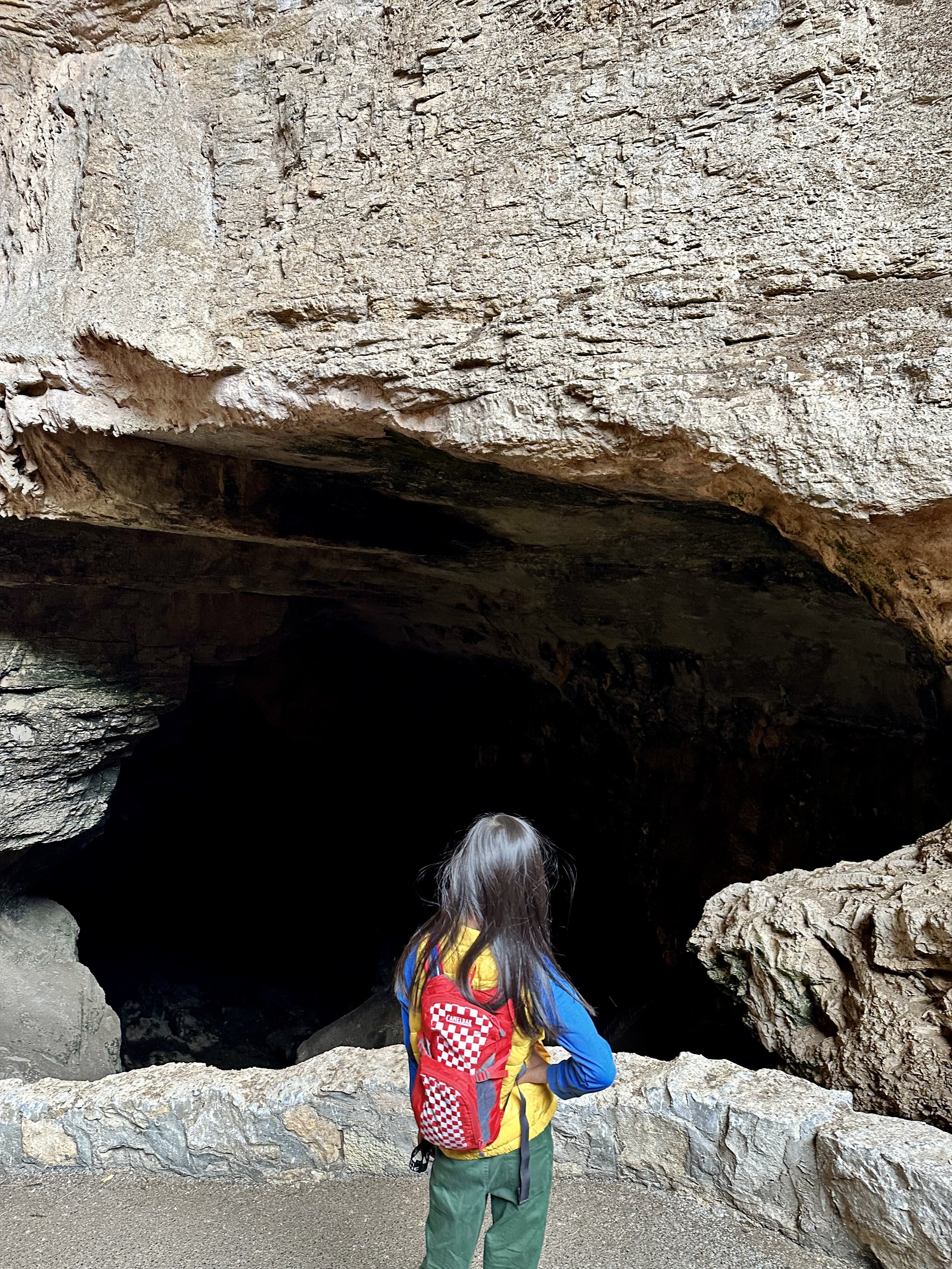
kiddo looking down into the natural entrance of carlsbad cavern
this post includes affiliate links. any purchases made from affiliate links may provide me with a small amount of compensation. it will not affect the price of your purchase.
it may sound odd, but carlsbad caverns was a major stretch for me. i am claustrophobic (yes, i’m living in a van with claustrophobia, lol), and being in the dark makes it so much worse. it makes me feel like i can’t breathe. for two days i was panicking about going into this darn cave.
as we descended into the natural entrance i was on the verge of a panic attack. and honestly, that feeling never really went away for the couple of hours we were down there. this cave is big. big, big. that helped minimize the claustrophobia, but the feeling of being buried alive never left. you can’t tell from these photos, but it’s pretty dark in there.
anyway, i survived to tell the tale and i’m sharing all the details on what we did with you! read on for my recommendations for carlsbad caverns national park, including our one day itinerary for carlsbad caverns.
land of the mescalero apache
the land presently known as carlsbad caverns national park is the indigenous homeland of the mescalero apache.
“in the Apache way of life, there is a belief that a dark side of life is present, as well as a light side. In the dark side of life there is misery, and nothing progresses for the Apache. here in the light of life there is happiness; a world God created of peace and harmony. In this world of peace and harmony, everything progresses for our people…
hundreds of years ago, long before white men came to this land, these mountains, plains and deserts belonged to the Mescalero Apaches… the Mescalero were essentially nomadic hunters and warriors, dwelling at one place for a temporary time in brush shelter known as a “Wicki up”; short rounded dwellings made of twigs or teepees made of elk hides and buffalo hides. the Mescalero roamed freely throughout the southwest including texas, arizona, chihuahua, méxico and sonora, méxico… today, three sub-tribes, Mescalero, Lipan and Chiricahua, make up the Mescalero Apache Tribe.”

in the big room of the cave in carlsbad caverns national park
what to bring to carlsbad caverns
shoes with good tread: the cave is moist and can be very slick, especially if you take the steep hike down into the carlsbad cavern natural entrance. whether boots or sandals, just make sure your shoes have good tread. here are the boots kiddo wore into the cave and the boots i wore into the cave. we had no issues but could definitely tell when we approached slippery areas.
headlamp: you’ll want to bring your own light into the cave, especially if you’re doing the natural entrance hike. eventually your eyes will adjust and the big room is better lit than other areas, but there were definitely spots where we needed light to find our way. we used these headlamps. we also have these little flashlights which are great for kiddos who may not fit the headlamps.
layers: the cave stays in the mid-50s year round, so you’ll want to bring an extra layer. nothing too heavy, but something to keep the chill away. kiddo wore a sweatshirt like this one. i wore my girlfriend fleece with an extra layer underneath and got a little warm.
a note about camping in carlsbad caverns national park
there is no lodging or campground in carlsbad caverns national park. overnight parking is not allowed. primitive camping is allowed in the backcountry only, and requires a free permit which is issued at the park's visitor center when you arrive (not reservable in advance).
we camped at a blm (bureau of land management) spot about 25 minutes from the park. there are several blm sites all in the same area, west of white’s city. it’s convenient to both carlsbad caverns and guadalupe mountains national park, as well as carlsbad, new mexico.
carlsbad caverns itinerary
it’s definitely possible to do carlsbad caverns in a day or even a half day. your first task will be to make a required reservation to enter the cave. from there, a major choice you’ll need to make is whether you want to do the steep, one mile hike down into the cave via the carlsbad caverns natural entrance hike. you can hike into the cave or take a short elevator ride directly to the big room. once you’re in the cave, you can do the full big room hike (1.25 mile) or take a shortcut hike (0.6 mile). there are occasional benches and rest areas inside the cave, and you’re welcome to spend as long as you like simply observing all the amazing formations.
you will also have the option to hike back out or take the elevator out. we chose to hike in, but because of the steep climb, chose to take the elevator back out. in total, we spend about 1.5-2 hours in the cave.
another key factor is what season you’re visiting. the carlsbad caverns bats are only in the park april-october. since we visited in winter, we missed the bats. the trip was still well worth it, but if you’re visiting any other season, you’ll likely want to plan around seeing the bats exit the cave at sunset.
and do be sure to check out some of the other areas outside the cave! the visitor center has great exhibits, and there are also other hikes and a scenic drive in the park. there’s lots to see beyond the cave! some recommendations for what to see in carlsbad caverns national park below!

in the big room of the cave in carlsbad caverns national park
one day in carlsbad caverns national park
visitor center: you’ll need to check in at the visitor center before you explore the cave. either show them your reservation or purchase tickets upon entering. we ended up spending more time in the visitor center than we typically do. there are some great interactive exhibits, some fun photo ops, and even a special area for junior rangers!
hike the natural entrance to the cave: you can certainly take the elevator into the cave and have an amazing experience. but for me, despite being terrified, hiking the natural entrance was my favorite part. there’s nothing quite like seeing that huge opening and then being swallowed up by the darkness at the entrance disappears behind you. the one mile trail is quite steep and can be slick in areas. there are interpretive signs and rest areas along the way.
hike the big room inside the cave: the big room is the best way to see all of the amazing formations inside the cave. the hike is about 1.25 mile and takes you through a number of fascinating formations, including the bottomless pit! there is a shortcut trail, as well.
hike the chihuahuan desert nature trail: you know i love a good interpretive trail about flora in the area! this one mile loop trail from the visitor center winds through the chihuahuan desert highlights. it’s also an opportunity to spot some of the park’s wildlife!
drive the scenic walnut canyon desert road: this 9.5 mile (one-way) dirt road drive takes you through the desert of of carlsbad canyon national park. it’s a great way to explore the less visited parts of the park and see the unique ecosystems above the caves. there are hikes along the way, too!
if you have more time in carlsbad caverns national park
.here’s a list of places we wish we could have visited if we had more time in the park.
take a ranger-guided cave tour
enjoy the bat flight program
take a desert hike
i hope this guide to carlsbad caverns national park inspires you to try something new, take a risk, do something you’re afraid of, and go out wild. no matter the season, there are amazing things to see at this unique national park!

favorite itinerary: visiting white sands national park
highlights for one day at white sands national park
this post includes affiliate links. any purchases made from affiliate links may provide me with a small amount of compensation.

kiddo hiking the dunes at white sands national park
white sands national park is exactly what all the bloggers and gram-ers say it is: like being on another planet. it is truly an unreal, bucket-list destination. the sand gets its color from gymsum, which washes into the basin from surrounding mountains. when the water evaporates, brittle selenite crystals are formed. the fragile crystals are easily ground down, creating the sand. while visiting white sands is a bit off the beaten path, it’s also a great park to do in a day or less and easy to visit if you’re passing through on a southwest roadtrip.
we spent about a half-day at white sands and probably could have done just about everything on our list in even less time. though, you could definitely spend a full day at white sands just wandering the dunes and taking it all in. or try camping at white sands national park to get the full experience! be sure to add this destination to your new mexico road trip itinerary!
land of the mescalero apache
the land presently known as white sands national park is the ancestral homeland of the mescalero apache. “the Mescalero people were nomadic hunters and gathers and roamed the southwest… the people were given the name "Mescalero" because they gathered and ate the mescal plant. It was the staple of their diets and could sustain them in good times and bad.”
a bit about the mescalero apache puberty rite ceremony:
"one of the most traditional and sacred ceremonies practiced by the Mescalero Apache is the puberty rite ceremony. it is a four-day “Rite of Passage,” a ceremony that marks the transition of an individual from one stage of life to another, from girlhood to womanhood. a young girl celebrates her rite of passage with family-prepared feasts, dancing, blessings and rituals established hundreds of years ago…
it is said that this ceremony was given to the Apache people by White Painted Woman. when her people, the Apache, were hard pressed by evil monsters, White Painted Woman reared a son to destroy those creatures and to make the earth inhabitable for mankind. she is the model of heroic and virtuous womanhood. for the duration of the rite, the young girl dresses and acts like White Painted Woman. the girl is never referred to by her name, but is known as White Painted Woman.
beginning at dawn on the first day, the young girl is guided and advised by a medicine woman through four days of formal observances and events… the girl is dressed in the buckskin costume that she will wear for the following eight days… by the end of the fourth day, every possible experience… has been mentioned in songs and prayers for the long life and good fortune for the young maiden and for the Apache people.
for four more days after the completion of the ceremony, the young maiden must continue to wear her ceremonial buckskins... at the end of this period the medicine woman washes her hair and body with suds of the yucca root. then she changes into her ordinary clothing, equipped for her new stage in life and her role in the community.”

gypsum dunes of white sands national park
what to bring to white sands national park
like any desert, exploring white sands national park calls for hydration and sun protection, no matter the season. a few things we alway bring for any desert hike:
sunscreen: this one is our favorite. it’s spf 50 and we like the mousse because it’s easy to apply, but you can also get the lotion or the mist.
water bottles: kiddo uses this camelpak on all our hikes. my current favorite water bottle is this one from wondery.
other sun protection: we recently purchased this buff for kiddo as a multi-use item. it protects his neck from sun but can also be worn in a myriad of ways, based on need. we most often use it as a headband! i wear a wide brim hat that i purchased from a shop years ago, but similar styles can be found here and here. also note, sunglasses are an absolute must at this park! the white sand reflects the sun and can really irritate your eyes!
good shoes: this is one of the few times i would recommend hiking sandals over boots, depending on the time of year you’re visiting white sands national park. otherwise, you’re gonna get a whole lot of sand in your shoes!i have these and kiddo wears these. because it was colder during our visit (and i hate getting my feet dusty/dirty), we still wore our boots and did just fun - though we had to dump out the sand at least half a dozen times during our visit! kiddo currently wears these hiking boots. i have high arches and am always alternating between boots. my two favorite pairs these days are these and these.

kiddo with sled for dunes sledding at white sands national park
a note about camping in white sands national park
there are no campgrounds in white sands national park, but there is the option to partake in backcountry camping in the dune field. the stars over the dunes create a memorable experience. permits are required and limited in availability.
white sands itinerary
unless you’re camping in white sands, you really can do this park in a day. we spent about 5 hours in the park and a good amount of that was just wandering around the dunes. it’s definitely possible to have a full experience in this park in half a day or less. however, there are some off the beaten path experiences even within the park, so if you have the time, enjoy 2 days in white sands national park! see some ideas for additional activities below.

kiddo hiking the backcountry loop in white sands national park
one day in white sands national park
visitor center: be sure to stop at the visitor center prior to entering as it’s the only place you can access water in the park. also check out the exhibits about the park’s geology. the white sands are truly unique and the process by which it forms is equally fascinating!
hike the dune life nature trail: kick off your adventure with this short interpretive hike through the dunes. it will give you a great initial sense for the dune experience while also bringing in the opportunity to see the wildlife that inhabits the park.
hike the interdune boardwalk: if you’re not up for hiking the dunes, this is a great accessible option just a little further on from the dune life nature trail. the boardwalk eliminates the need to trudge through sand, but still provides the opportunity to get out into the dune field. there is also a ton of great interpretive information along the way. we did both (along with the playa trail!), and enjoyed them equally.
go dunes sledding: you can’t miss this memorable experience! we first went dunes sledding at great sand dunes national park and it was the highlight of the entire summer for kiddo. so, we knew we had to do it again when the opportunity to visit white sands national park arose. visitors are essentially given free reign to pick explore any spot on the dune field and turn it into a sledding hill. you can spend as long as like and have the energy to keep trudging back up the dunes! note - i highly recommend bringing your own sleds, if that’s an option for you. the sleds available in the gift shop are quite pricey and it wasn’t an option to rent while we were there.
hike the backcountry loop trail: after sledding we took a break for lunch to refuel. there are several picnic areas throughout the dune field, but we chose to pull off in a quiet spot and enjoy the view. from there, we hit the backcountry loop trail! there are diverse options for hiking in white sands national park, from boardwalks, to those with more flora and fauna, to those with endless, pristine dunes. this hike in white sands is of the endless, pristine dunes variety. while the parking area of this hike can get quite busy, you’ll find that the crowds quickly fall away as you proceed on the trail. the trail is well marked, but you also have the option to wander as far as you like. we saw virtually no one else and were completely immersed in the dunes. this was my favorite experience at white sands national park, though be advised it’s over two miles of trudging through sand, up and and down the dunes. it’s an energy zapper, for sure!

kiddo walking across the top of a dune at white sands national park
if you have more time in white sands national park
join the ranger guided sunset stroll - we had planned to do this but had to drive back to camp to get a spot! we’re still bummed we missed it.
hike the strenuous alkali flat trail - this is the longest and most strenuous hike in the dune field
score tickets to the lake lucero tour - this tour only happens a few times a year. we had tickets to go in fall one year and sadly had to bail on that trip. we still hope to go back and do this. if you’re able, try to plan around the rare dates that this tour occurs.
i sincerely hope this guide to white sands national park encourages you to go out wild and explore this otherworldly place. i’ve experienced nothing else like it, despite visiting plenty of other sand dunes. it’s a really special place and a great option for a family vacation. enjoy!

favorite itinerary: visiting chiricahua national monument
favorite hikes at this southeastern arizona national monument
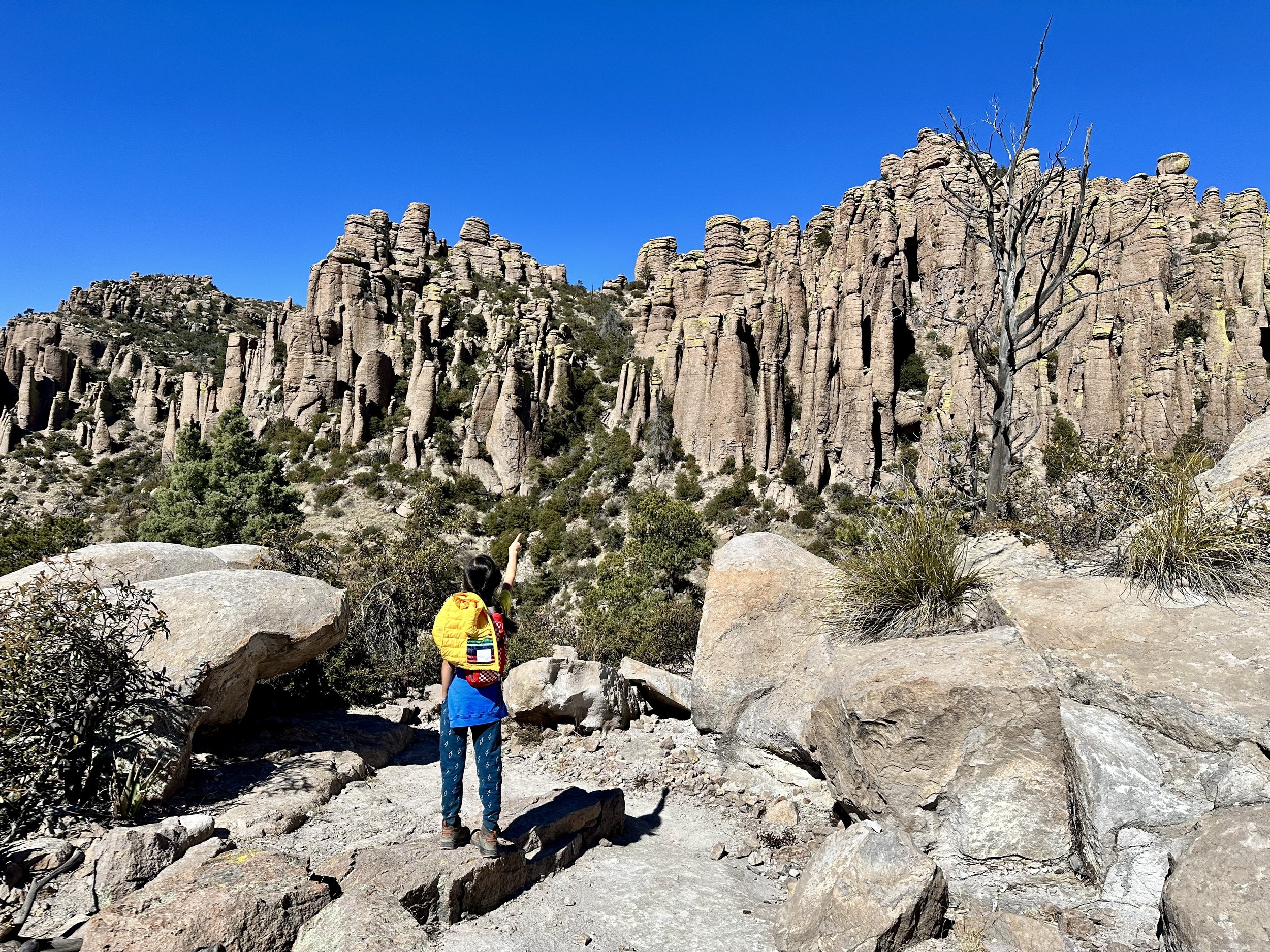
kiddo points up at the rhyolite formations in chiricahua national monument
this post includes affiliate links. any purchases made from affiliate links may provide me with a small amount of compensation. it will not affect the price or other terms of your purchase with the vendor.
ever wonder what would happen if bryce canyon and pinnacles national parks got together and had a baby? for the very select few who said “yes!”, i have the answer for you! it’s chiricahua national monument, and it’s in southeastern arizona.
chiricahua national monument is an extraordinary surprise in far eastern arizona. with otherworldly rhyolite formations, exciting grottoes, and plenty of trails, it’s a great addition to any arizona road trip or southwest vacation!
land of the chiricahua apache
the land presently known as chiricahua national monument is the indigenous homeland of the chiricahua apache. it’s important to note that when they were given the name “apache” by the spanish, it was not a name the indigenous people took on. instead, they used variations of “nde”, meaning “the people”, to refer to themselves. since then, the tribe has claimed the name and are outwardly identified as the sovereign nation of the chiricahua apache. (it’s also worth noting that not all indigenous peoples who were assigned “apache” find the term acceptable.) a little about the chiricahua apache’s origin beliefs:
“the chief deity of the Chiricahua Apache was Ussen, whose will governed all. Ussen existed before the creation of the universe. He created the first Mother with no parents who sang four times, a sacred number to the Chiricahua Apache. Her singing began the creation of the universe. Ussen also created the first Boy and Sun God who shook hands. the sweat from this handshake created the Earth. the Earth was small at first, so they kicked it around and it gained mass like a snowball rolling down a hill, getting larger and larger. Ussen also created Tarantula, who increased the Earth’s size even more by pulling on it with four cords of web which he spun. Ussen then created the first people and fire and then he left. Ussen continues to watch events unfold from afar and still intercedes from time to time.”
what to bring to chiricahua national monument
kiddo hikes up sugarloaf mountain in chiricahua national monument
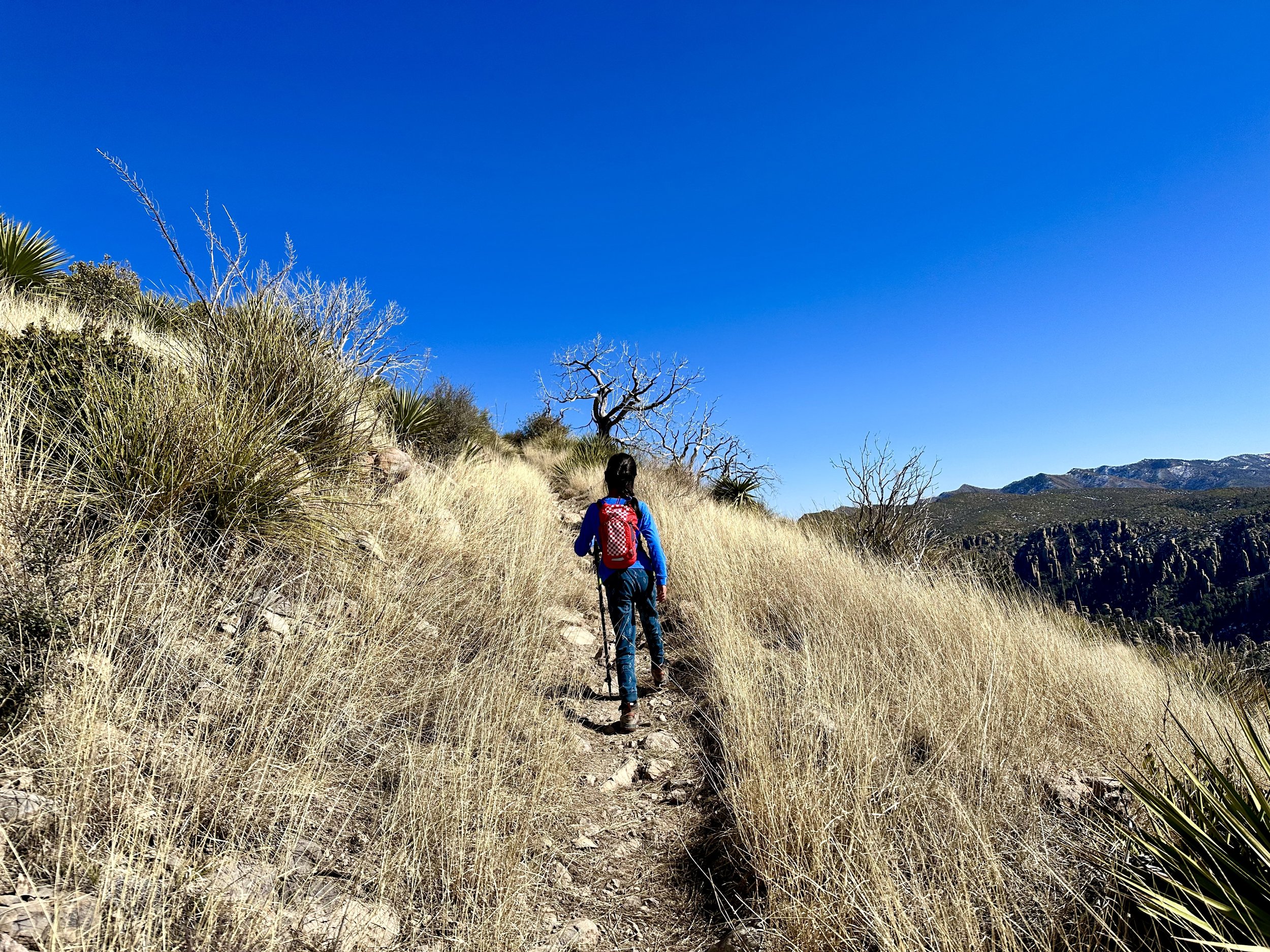
chiricahua national monument sits at higher elevations than the surrounding areas in arizona. because of this, it tends to be cooler and layers are recommended for much of the year. while it can get warmer in summer, chiricahua national monument does experience all four seasons. we visited in february and it was in the 20s. the roads were clear, but there was still snow and ice on some of the trails.
base layers: wool base layers will keep you comfortable while exploring this park. i have this top and these bottoms from smartwool, which are best for cooler temps. there’s also this lighter weight top and these lighter weight bottoms which are great for year round! (yes, these are pricey. i will say i absolutely love them and they work exactly as they should, along with being super comfy. i highly recommend them!)
microspikes: if you’re visiting in winter, you’ll definitely want to bring microspikes. while we saw some snow and ice on most trails, one of the trails we did was extremely icy and we would have fared a lot better with microspikes. these look good for adults and here’s a great option for kids.
hiking poles: though we didn’t have microspikes, we did have our hiking poles on hand, and they were an absolute lifesaver. i highly recommend these for any season as most of the trails are fairly rocky with some rough terrain.
good shoes: i also highly recommend sturdy boots. kiddo currently wears these hiking boots. i have high arches and am always alternating between boots. my two favorite pairs these days are these and these. in warmer weather you could likely get away with some good hiking sandals in this park. i have these and kiddo wears these.
a note about camping in chiricahua national monument
there is an option to go camping in chiricahua national monument. there is just one campground in chiricahua that is largely for tents or vans, though some spaces could fit smaller rvs. there are no hookups or dump stations. restrooms and potable water are available. it’s very near to the chiricahua national monument visitor center.
because of the very low temperatures, we opted not to camp in chiricahua national monument. however, the campground was still completely full when we visited!

kiddo hiking a trail in chiricahua national monument
chiricahua national monument itinerary
there’s a fair amount to explore in chiricahua national monument, and 2 days in chiricahua or 3 days in chiricahua national monument would probably be ideal. we only had one day and because it was winter there weren’t any program options to take part in. so, we went hiking - a lot! if this much hiking isn’t for you, check out the “if you have more time” section below for what to do in chiricahua national monument.
one day in chiricahua national monument
visitor center: start out the visitor center, especially if you are visiting in winter. they will have information about the latest trail conditions and can help you decide which trails are best for your group on the given day.
hike massai point nature trail: drive the bonita canyon scenic drive to the upper elevations of the park at massai point. here you’ll find a nice nature trail that will bring all the wonder and excitement about exploring the park’s rhyolite pinnacles further. note - these are several interesting pullouts on the way up. i recommend stopping at these on the way down because they are on the opposite side of the road and have extremely limited parking and visibility.
hike sugarloaf mountain trail: make your way back down bonita canyon drive to the turnoff for echo canyon and sugarloaf mountain. after turning you’ll quickly come to another turn for echo mountain. keep heading up - you’re going to hike the highest point in the park: sugarloaf mountain! this trail brings sweeping views the whole way and takes you to an old fire lookout. once you’re back down, take a nice break and enjoy a picnic lunch before heading back down the road to the echo canyon loop trailhead.
hike echo canyon loop: this is an absolutely fabulous trail that takes you right down into the pinnacles. while sugarloaf mountain has steeper elevation gain, this hike was definitely the toughest of the three - we’d rate it moderate. we hiked it clockwise, which kept the best part for near the end: the grottoes! if you don’t have much time, you should start counterclockwise, hit the grottoes and then turn back. they are absolutely worth seeing if you’re able! note - this loop is made up of a series of trails by differing names. be sure to bring your map. the intersections are well marked, but it can be confusing because you’re technically transitioning to a new trail at each one.
checkout the viewpoints on the bonita canyon scenic drive: on your way back down bonita canyon drive, take the opportunity to stop at the pullouts along the way. our favorite was the organ pipe formation, which was a fun coincidence since we had just visited organ pipe cactus national monument (itinerary here)!

kiddo enters the grottoes at chiricahua national monument
if you have more time in chiricahua national monument
one of the things we regret is not having more time for wildlife viewing, which is much more likely in the lowest elevations of the park. here’s a list of places we wish we could have visited if we had more time in the park.
visit faraway ranch historic district
view the wildlife at bonita creek
hike the natural bridge trail
hike the silver spur meadow trail
i sincerely hope this guide to chiricahua national monument encourages you to go out wild and explore this fascinating place. i found myself oohing and aahing a whole lot more than i expected and hope you experience the same!

favorite itinerary: visiting organ pipe cactus national monument
best things to see at my new favorite national park service site

kiddo hiking in organ pipe cactus national monument
this post includes affiliate links. any purchases made from affiliate links may provide me with a small amount of compensation. it will not affect the price or other terms of your purchase with the vendor.
my friends, i have a new favorite national park service site: organ pipe cactus national monument. we had some major snafus while visiting this extraordinary biosphere preserve and yet i am still completely taken by its magic. have you ever heard of this far southwestern arizona national monument? i cannot rave enough about this gem. organ pipe cactus national monument is truly a national treasure!
organ pipe cactus national monument is in the sonoran desert, which benefits from two rainy seasons. and though it’s still desert, it’s called the “green desert” for good reason. this park is absolutely teaming with a diversity of flora. it honestly stunned me. seriously, friends, i teared up multiple times on our first hike because it is so dang beautiful!
the organ pipe cactus is rarely found in the united states - organ pipe cactus national monument is really the place to see them. this monument is also an international biosphere preserve, and there are other species that can only be found in this part of the country, including the endangered sonoran pronghorn. there are so many special moments to be found here. for example, when the wind blows, the organ pipe cacti needles hum. they not only look like organ pipes, but they actually make music! i cannot recommend enough that you add organ pipe cactus national monument to your southwest trip itinerary!

organ pipe cactus ribs at organ pipe cactus national monument
land of the tohono o’odham
the land presently known as organ pipe cactus national monument is the indigenous homeland of the tohono o’odham. the tohono o’odham nation continues to reside and thrive in the area. while we learned so many fascinating facts about how the tohono o’odham use mesquite and tepary beans, as well as other desert resources, I was naturally taken by the uses of cactus. here’s a favorite thing we learned:
“early spring was called ko’oak macat (the painful moon) by the tohono o’odham becaues of scarce food supplies. during this season, they turned to cacti for food and pit-roasted thousands of calcium-rich cholla flower buds. today’s o’odham people still pit-roast or boil the cholla buds, which taste like asparagus tips.”
what to bring to organ pipe cactus national monument
like any desert, exploring organ pipe cactus national monument calls for hydration and sun protection, no matter the season. a few things we alway bring for any desert hike:
sunscreen: this one is our favorite. it’s spa 50 and we like the mousse because it’s easy to apply, but you can also get the lotion or the mist.
water bottles: kiddo uses this camelpak on all our hikes. my current favorite water bottle is this one from wondery.
other sun protection: we recently purchased this buff for kiddo as a multi-use item. it protects his neck from sun but can also be worn in a myriad of ways, based on need. we most often use it as a headband! i wear a wide brim hat that i purchased from a shop years ago, but similar styles can be found here and here.
good shoes: the desert is fully of prickly things. i highly recommend sturdy boots (and not hiking sandals). kiddo currently wears these hiking boots. i have high arches and am always alternating between boots. my two favorite pairs these days are these and these.

sunset on ajo mountain drive
a note about camping in organ pipe cactus national monument
i highly recommend camping in organ pipe cactus national monument. the monument is right on the us/mexico border and there are very few services in the surrounding area outside the park. organ pipe cactus national monument has two campgrounds - the larger twin peaks campground, as well as the tiny, more primitive alamo campground. we camped at twin peaks and really loved it. it’s just one mile from the organ pipe cactus national monument visitor center, is accessible to several trails, and is just steps from the amphitheater where ranger programs are held.
i recommend 2-3 nights in organ pipe cactus national monument so you can see the top sites and take in the best spots. here’s our itinerary for two days in organ pipe cactus national monument.
2 days in organ pipe cactus national monument
you certainly could spend one day in organ pipe cactus national monument and see a lot. if you only have a day, use the day 1 itinerary as your complete guide to organ pipe cactus national monument.
day 1: one day in organ pipe cactus national monument

kiddo hiking arch canyon trail
visitor center: start at the kris eggle visitor center. be sure to check out the garden in back to get a close up look at a saguaro boot! note, this park has a desert ranger program, rather than a junior ranger program, but the swearing in and badge are just like you’d expect from other parks. not gonna lie, it was fun to partake in activities more geared for adults, and i got a badge, too!
ajo mountain drive: make your way just across the road from the visitor center to ajo mountain drive. this 21 mile winding, scenic road has 18 stops with an interpretive map. also be sure to grab the desert ranger guide to find the cristates, a crest-like anomaly in cacti, throughout this section of the park!
hike arch canyon: just past stop 10 on your drive you’ll come to the arch canyon trailhead parking. at 1.2 miles and marked “easy to moderate” you might be tempted to think this is a quick stop. i would consider this hike to be on the more strenuous side as a significant portion of it is quite steeps and requires scrambling. also note, there are a lot of cairns on this trail that may seem helpful but ended up leading us hours off trail. we were in a very near dangerous situation with no more water and the sun going down before we finally found our way back to the trail. be sure to download a map in advance as there is no reception in this area! and please, never build cairns. they are ecologically damaging and not always helpful to fellow hikers. all that said, if you stick to the trail, it’s a lovely adventure that’s mostly shaded in the afternoon.
hike estes canyon: between stops 11 and 12 is a picnic area with restrooms, as well as the trailhead for estes canyon and bull pasture. enjoy a picnic lunch to refuel between your hikes. the estes canyon loop is about 3 miles. if you’re feeling up for it, you can add on the bull pasture spur for an additional mile that’s quite strenuous. from there, finish up the rest of the scenic drive, including my personal favorite part, the cholla forest!
evening ranger program: after you’ve gotten some rest and dinner, head over to the amphitheater where the park hosts a ranger program most evenings. the program we attended was about how the ecosystem has changes over millions of years. we learned a ton, including the fact that this section of desert as we know it is younger than the humans who have occupied it!
day 2: two days in organ pipe cactus national monument

kiddo hiking the desert view trail
puerto blanco drive: this 41 mile drive circles the puerto blanco mountains and offers the opportunity to visits multiple springs and an oasis. there are also several hiking opportunities, but be mindful that this drive is much longer and your time on trails may be limited.
hike dripping springs mine: though the spring is a nice area to take in some cool air, the real gem of this hike is the extraordinary views! this is another trail that requires a map as it’s not well marked and the cairns can be misleading. after your hike continue on to golden bell mine or bonita well for a picnic lunch.
visit quitobaquito spring: after lunch, continue your drive and make a stop at this pond that was once part of a prehistoric trade route. there are several endemic species here, as well the sonoyta mud turtle, which can only be found here in the united states. finish up the drive from there!
hike desert view trail: after you refuel and get some rest, i highly recommend taking a golden hour or sunset hike on the desert view trail. accessed from the group sites at twin peaks campground, this was our favorite hike in the park. it’s a really lovely place to take in the scenery, learn about the various plants and just enjoy a gentle farewell to this special place.
i sincerely hope this guide to organ pipe cactus national monument encourages you to visit go out wild and explore this special place. it exceeded all my expectations and i had very high hopes going in!

favorite itinerary: visiting channel islands national park
one day itinerary for santa cruz island

kiddo hikes to potato harbor on santa cruz island
this post may contain affiliate links. affiliate links do not affect your purchase price but may provide me with a small amount of compensation.
visiting channel islands national park was like a dream come true! of the nine california national parks, i definitely assumed visiting channel islands would come last. alas, life has its way of changing plans, and we were able to make a trip to channel islands national park the first stop on our unexpected coast to coast road trip.
indigenous land
the channel islands are the indigenous homeland of the Chumash. Julie Tumamait-Stenslie, an island descendant, shares a Chumash creation story:
"Saxipaka, once upon a time, here on this beautiful island that we call Limuw, meaning "in the sea", we know it today as santa cruz island. Mother Earth, Hutash, was out here. and as she had created many things here on the island, she thought something was missing. so she went to a very special plant, and she gathered some magic seeds. and she threw the seeds out into the earth, here on the island. and pretty soon, up from the ground, up from this beautiful earth, grew these beautiful people. she gave them many gifts here, and showed them how to live happily on this island. well, her husband, Suyapo'osh, the sky snake, today we know him as the milky way, he wanted to give the people a gift too, so he gave the gift of fire by shooting a bolt of lightning to the ground. well, the fires burned hot, and they kept warm with these fires, and they cooked their food. the villages started to grow and grow and be populated with more and more children. pretty soon, with all the noise from these children, Hutash was annoyed. and she decided that it was time for these people to move on, and to move to another place. so she said to herself, I've got to think of some place to put these people, a different place where they can spread out and be very happy. well the next morning she gathered all the people up to a very high, high mountain, Siwot, or as we know it today, mount diablo. and as she told the people to look, and as they looked up into the sky across the ocean, they saw a beautiful, beautiful rainbow, Wishtoyo, and she told them that image was a rainbow bridge. and the rainbow bridge was going to take them to a new land that was very large, and they could fill that with people. well, as the people started to climb over the bridge and cross over, many became very dizzy and very frightened, because there was a mist and a fog below - they couldn't even see the ocean. well, as they started falling off, crying to Hutash for help, she took pity, and she changed them and transformed them into dolphins, and that is what we call our brothers and sisters today of the ocean, Alolk'oy. those people who crossed over on the bridge went to a place called Ts'ismuhu, "where it steams out." today we know that place as carpinteria. and the people came off that rainbow bridge and spread out into all these beautiful places on our mainland. and that is all."

two dolphins jumping out of the water in the santa barbara channel
channel islands national park is made up of five islands. the largest, easiest to get to, and thus most frequently visited is santa cruz island. because we visited during winter, santa cruz island was our only option due to limited ferry runs. ferries to the island are hosted exclusively by island packers. the winter ferry left the ventura dock at 9am, arriving on santa cruz island by 10:30am. the only ferry back to ventura departed santa cruz island at 3:30pm. so, we had a total of five hours on the island.
what to bring to channel islands national park
importantly, there are no concessions on the island - no food options or gift shop. you’ll want to bring all the food you’ll need for the day with you. i packed lunch and some extra snacks in my daypack here. there is water available at the campgrounds, but many of the hikes get quite a distance from the campgrounds, so be sure you fill up with all the water you’ll need before hitting the trails. i brought a 32 oz. water bottle and kiddo had his camelpak here. if you end up forgetting anything or want some extras, you can purchase some items on board the ferry before you disembark.
a note: kayaking channel islands
we would have loved to do kayaking at channel islands national park! because of the ferry schedule, and availability of kayak tours, this is the only activity we would have had time for if we signed up. we really wanted to do some channel islands hikes and have the opportunity to explore on land, so we opted out. having been on the island, i’m glad for this decision, but if we had an extra day i would absolutely do a kayaking tour of channel islands!
a note: camping at channel islands national park
there is one primitive campground on each of the five channel islands! all have pit toilets and picnic tables but only santa cruz and santa rosa islands have potable water. all campgrounds are located away from the boat launch, so you must essentially backpack in with your gear. we checked out the santa cruz island campground up close (and the anacapa campground from afar), and i am very eager to return to camp someday!
and with that, here’s our itinerary for one day on santa cruz island.

standing in front of the channel islands national park sign at the boat launch
one day at channel islands national park: santa cruz island itinery
channel islands visitor center
it’s important to note that the channel islands visitor center is located on the mainland, near the ferry dock in ventura. there are ranger outposts at each of the five islands, but none are places where anything can be purchased - or even where there is a ranger posted. because you need to check in at the ferry before the visitor center opens and then return right around when it closes, it’s best if you can swing by the channel islands visitor center the day prior to your island excursion. we lucked out and our santa cruz island ferry got back just after 4:30pm and were able to hustle over to the visitor center (it’s down the road from the dock). we were able to explore the channel islands visitor center a bit and make purchases just before closing. however, because the ferry stops for animal sightings (yay!), your ride could last up to two hours and you could miss open hours altogether.
island packers ferry ride to channel islands

view from the channel islands ferry
board the morning ferry to santa cruz island! since we visited in winter, there was only one ferry to any of the the islands the entire day - and it was to santa cruz. during busier seasons there will likely be more options. i’d absolutely recommend taking the earliest ferry possible, though.
the ride to santa cruz island is about an hour, but if you’re lucky it will take longer because the ferry stops for animal sightings. we were fortunate to have a couple grey whale sightings. our ride to santa cruz island took about 75 minutes.
note: if you get sea sick (i do!), sit outside at the back of the boat. i am very prone to motion sickness, and i did great sitting back here and not moving. you’re also closest to the bathrooms, should the need arise.
hiking channel islands: interpretive hike to cavern point
cavern point trail on santa cruz island
after we disembarked, we took the obligatory photos at the national park sign (there are actually two on island! keep reading to discover where the second is). we had a few minutes to use the restroom and collect ourselves before a guided interpretive hike with a channel islands naturalist. our guide, bart, has been visiting the islands for 15 years and was able to share some of the significant changes (good ones!) he’s witnessed over that time.
the interpretive hiking trail was the cavern point loop. during our leisurely (though uphill!) walk we learned about many of the over 150 channel islands endemic species, as well as the ranching history of santa cruz island. we hiked with the group to cavern point and then split off to do another hike on our own.
best hikes channel islands: potato harbor at santa cruz island

potato harbor at santa cruz island
we ate our sandwiches while making our way from cavern point to the potato harbor trail on santa cruz island. potato harbor is a five mile hike that takes you along the coastline, through stunning grasslands to an overlook above a beautiful cove. we were pretty enchanted with the whole hike. it’s relatively flat and brings near-constant sweeping views. we saw lots of evidence of the endemic island fox along the way, as well as many of the island’s endemic plant species. we took a snack break at the end point and took in all the beautiful views before heading back toward the boat launch. we’d definitely rate this as one of the best hikes on santa cruz island and one of the best hikes of channel islands, overall!
santa cruz island visitor center
we had a bit of time left after our hikes, so we went to explore the on-island visitor center. again, this visitor center isn’t the same as the typical national park visitor center with souvenirs, books, a ranger desk, etc. there was no ranger inside, at all, and nothing to purchase. it is more of a museum that highlights the chumash, the indigenous people of the islands, the ranching history, and the conservation efforts of various species. we especially loved learning about the chumash and the island fox.
santa cruz island beach play

finally, we headed to the beach to play a bit on shore. there’s actually another channel islands national park sign right on the beach! we saw lots of birds, a sea urchin, and a few playful sea lions! it was the perfect way to spend our last minutes at channel islands natural park.
channel islands ferry back to mainland
it’s time to depart santa cruz island! there was only one ferry to the island and one ferry back. our ride back to mainland was at 3:30pm. if you miss the boat, you have no option but to stay overnight. from what was repeated multiple times, this has happened before. however, they did have a list of expected passengers and waited until everyone on the list was on board. our return ferry was faster as we didn’t have any animal sightings (other than the silly sea lions while we were boarding). it ended up taking just about an hour to get back.
since we had enough time, we went straight to the channel islands visitor center in ventura after disembarking! also, for those doing the junior ranger program - we got our book from island packers in the morning and our channel islands naturalist had been deputized to give badges. so, on our ferry ride back he reviewed kiddo’s book, swore him in and presented his pin.
it was a long but thrilling day at channel islands national park! but, we had one more day to explore the area, so we went whale watching!
channel islands day 2: island packers whale watching

two dolphins in santa barbara channel
since we opted out of kayaking the channel islands, we decided to spend another day doing a whale watching tour. one of the benefits of visiting in winter is you can catch the grey whale migration! we used island packers again and did a half day excursion that took us out to anacapa island and back. we had seen grey whales the day prior, but on our tour we actually saw humpback whales! the crew said they hadn’t seen humpbacks a long time and we saw quite a few, so it was a big day! we also saw hundreds and hundreds of dolphins. they absolutely love surrounding the boat, so we got some pretty up close interaction with them which was a thrill! we really enjoyed our tour and highly recommend it!
important tip: be sure to bring sunscreen! even on a winter day, the water reflects the sun quite strongly. this is our favorite sunscreen that we bring on all our adventures. we love the mousse for easy application, but you can also get the lotion or the spray.
visiting channel islands national park was such an incredible adventure. we are so grateful we were able to make it happen and are hoping to return soon to try out camping on channel islands.
i hope this itinerary for one day at channel islands national park’s santa cruz island helps you plan your own adventure. let me know if you’ve visited and what else you’d add to this list! have a great time and go out wild at channel islands national park!
pin this post for later

favorite places to hike near palm springs; best hiking areas beyond joshua tree national park
recreation areas near palm springs we return to again and again

kiddo hiking in anza-borrego desert state park
when we lived in the palm springs area, we were able to hike every weekend without running out of trails to explore. while we absolutely loved - and continue to love - visiting joshua tree national park, there are are so many incredible areas in both the low and high desert for hiking. (for hiking in joshua tree national park, see this post about joshua tree hidden gems!)
while the coachella valley does get exceedingly hot in summer, the rest of the year brings perfect hiking temperatures. plus, the valley is surrounded by multiple mountain ranges, so there are tons of higher elevation (read: cooler) hiking and recreation opportunities a bit further out. here are our favorite hiking areas in and near palm springs, california, including our favorite trails in palm springs and beyond.
whitewater preserve
the nearly 3,000 acre whitewater preserve is surrounded by san gorgonio wilderness and provides a rich riparian habitat for bighorn sheep, migrating birds, and many other beautiful creatures. there are 4 main trails, ranging from 3.5 to 8 miles, as well as connectors to the PCT and other trail systems. a favorite trail is the 4 mile whitewater canyon loop. there's also a campground and a beautiful recreation area that provide the opportunity for enjoyment without hiking. it’s a great place to cool down on a warm day if you’re looking to get away from the pool.

kiddo and i hiking through the whitewater river
big morongo canyon preserve
like joshua tree national park, big morongo canyon preserve encompasses both mojave and colorado deserts. it's also one of the largest cottonwood and willow riparian habitats in california. part of the sand to snow national monument, this 31,000 acre preserve remains one of our favorite hiking areas of all time for it's diversity of flora and fauna. there are 6 trails that traverse different ecosystems, including the marsh trail and canyon trail. visitors can combine them in any number of ways to create just the right adventure. we’ve been on all 6 trails multiple times and love each one. no matter the season, there is always something beautiful to experience here!

kiddo hiking the yucca ridge trail at big morongo canyon preserve
indian canyons
managed by the agua caliente band of cahuilla indians, indian canyons affords visitors 60 miles of gorgeous trails through 3 different canyons. our favorite trail, the palm canyon loop, winds through the world's largest naturally occurring oasis of the california fan palm and then up out of the canyon for spectacular panoramas. once we saw a tarantula on the trail! for a shorter hike through another oasis, check out the 1.2 mile andreas canyon loop. and for a longer hike, try the murray canyon trail, which features more than a dozen creek crossings to a waterfall. another canyon in the area worth a visit is tahquitz canyon, which is also managed by the tribe and features tahquitz falls during the wet season.

kiddo hikes up the ridge of the palm canyon trail
santa rosa and san jacinto mountains national monument
at 280,000 acres, the santa rosa and san jacinto mountains national monument is BIG - and offers endless hiking opportunities! with more than 200 identified cultural resources and over 11,000 feet in elevation change from lowest to highest points, there is an incredible amount of adventure to be experienced here. some of the area continues to be owned by the cahuilla indians and management is shared across several different agencies. do your research to find the best hiking options in the area, along with associated fees and regulations. here are some of our favorites across the area:
palm springs: the 1.6 mile out and back museum trail climbs over 800 feet in less than a mile. the more challenging 4.1 mile araby trail has 1400 feet on elevation gain and thus comes with excellent views.
palm desert: we love the 2.7 mile randall henderson loop. for a little more challenge, try the 4 mile bump and grind trail.
mt. san jacinto: take the palm springs aerial tramway for the round valley or desert view trails. it’s beautiful up here no matter what trail you take!

kiddo hikes the bump and grind trail in palm desert, ca
hiking areas a bit further out
though a bit further out, both of these locations are well within range for a day trip from palm springs. anza-borrego desert state park is especially lovely in the spring. head up to idyllwild in summer to escape the heat or in winter to enjoy snow.
anza-borrego desert state park
we first visited anza-borrego desert state park during the 2019 wildflower superbloom. it was easy to fall in love with the park when it was blanketed in colorful blooms, but we’ve returned multiple times since then to enjoy this beautiful desert wonderland. our two favorite trails are near the tamarisk grove campground: cactus loop nature trail and yaqui well nature trail. it was on one of these trails we saw our first desert tortoise in the wild!
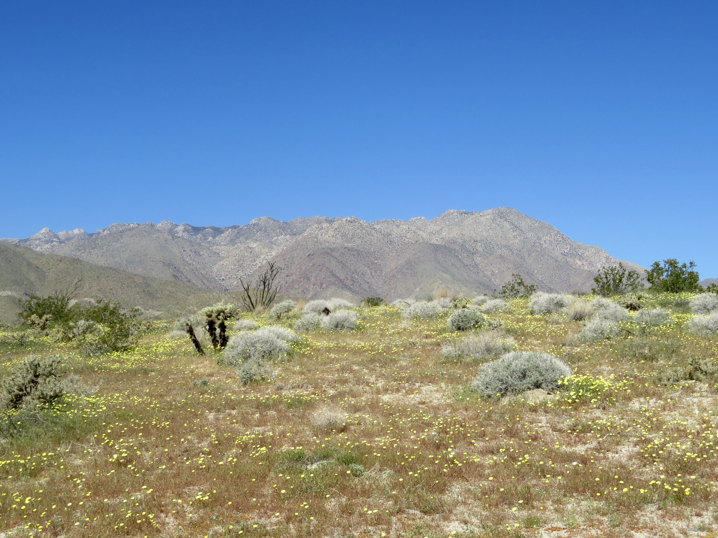
desert dandelions blooming in anza-borrego desert state park
idyllwild
this quaint mountain town is a great day-trip escape from the desert heat. there are many hiking trails in the area, but be advised most are longer day hikes. for a more moderate option, try the 4.6 mile ernie maxwell scenic trail. there are also lots of options to visit recreation areas for short nature walks and relaxation in picnic areas. be sure to visit the idyllwild nature center!
pin this post for later!

favorite hidden gems in joshua tree national park
less frequented spots in our favorite national park

kiddo runs through the boulders at joshua tree national park at sunset
this post contains affiliate links. purchasing from these links will not affect your purchase. however, i may receive a small amount of compensation for any purchases may through these links.
joshua tree is truly my favorite place on earth. no matter how many times we go, i always look forward to the next visit. and, after living close by for nearly three years and then returning one to two times a year since then, we’ve been to joshua tree national park at least two dozen times. while i can’t say we’ve seen every nook and cranny, we’ve seen an awful lot. we’ve been to all of the popular spots - some many times - and they are absolutely worth visiting! but now when we visit joshua tree, we try to find less frequented spots like longer hikes or places on the edge of the park’s borders.
indigenous peoples
the land presently referred to as joshua tree national park is the traditional homeland of many tribal peoples, including the cahuilla, serrano, mojave, and chemehuevi. per an enthographic study performed by the park, “the Chemehuevis had something that resembled a moiety system associated with the ownership of land in demonstrated in two hereditary songs, the Mountain Sheep Song and the Deer Song, each of which described trips through the mountains and valleys along the colorado river. those who had the right to sing the song had the right to hunt in the area and in that sense owned it. the songs were inherited patrilineally, but after the euro-americans came a man might inherit his song from his mother's father if his father were a non-Indian and thereby had no song, and, therefore, presumably no right to use the economic assets thereof.
groups of Chemehuevis had a right to hunt in a Mountain Sheep area only if a man who was an owner of the Mountain Sheep Song was part of the group. the same was true of the Deer Song. the Mountain Sheep Song covered an area west of the colorado river, and the Deer Song, east of the river. the Salt Song was associated with the Deer Song, and was often owned by those who owned the Deer Song, but it involved both sides of the river. each song had subdivisions, and a subgroup might own only a subdivision of a song, and a specific version of it… only a person who owned a song could sing it ritually, but others could sing it in non-ritual contexts.”
descendants of the chemehuevi, the twenty nine palms band of mission indians, settled at the oasis of mara, a sacred site near twenty nine palms. the oasis of mara can be visited by guests to joshua tree national park. be sure to go to the cultural center to learn more about this history, the ongoing importance of the site, the original stewards of the land, and the continued role of their descendants.
what you’ll need to visit joshua tree
joshua tree is, of course, a desert. water and sun protection are of the utmost importance, no matter the season. a few things we alway bring:
sunscreen: this one is our favorite. it’s spa 50 and we like the mousse because it’s easy to apply, but you can also get the lotion or the mist.
water bottles: kiddo uses this camelpak on all our hikes. my current favorite water bottle is this one from wondery.
other sun protection: we recently purchased this buff for kiddo as a multi-use item. it protects his neck from sun but can also be worn in a myriad of ways, based on need. we most often use it as a headband! i wear a wide brim hat that i purchased from a shop years ago, but similar styles can be found here and here.
good shoes: the desert is fully of prickly things. i highly recommend sturdy boots (and not hiking sandals). kiddo currently wears these hiking boots. i have high arches and am always alternating between boots. my two favorite pairs these days are these and these.
a trip to joshua tree national park is truly an adventure, and you’re sure to find something special no matter what. these are some of our favorite hidden gems in joshua tree national park, along with a couple of the hot spots that are worth returning to again and again.
favorite hidden gems in joshua tree national park

the view from lucky boy vista at sunset
lucky boy loop
we hiked this 3.3-mile loop just before golden hour so we could get to lucky boy vista at sunset. we ate our trail dinner while watching the sunset over the vista point, and then raced back down, getting to the car just as the sky turned dark. and then it was just us and the stars. it’s one of our favorite memories in the park. if you’re traveling park boulevard, the turn off for this hike is between ryan mountain and jumbo rocks, so it’s in an area you are likely to travel at some point during your visit. if you bring binoculars, you can spot skull rock from the vista.

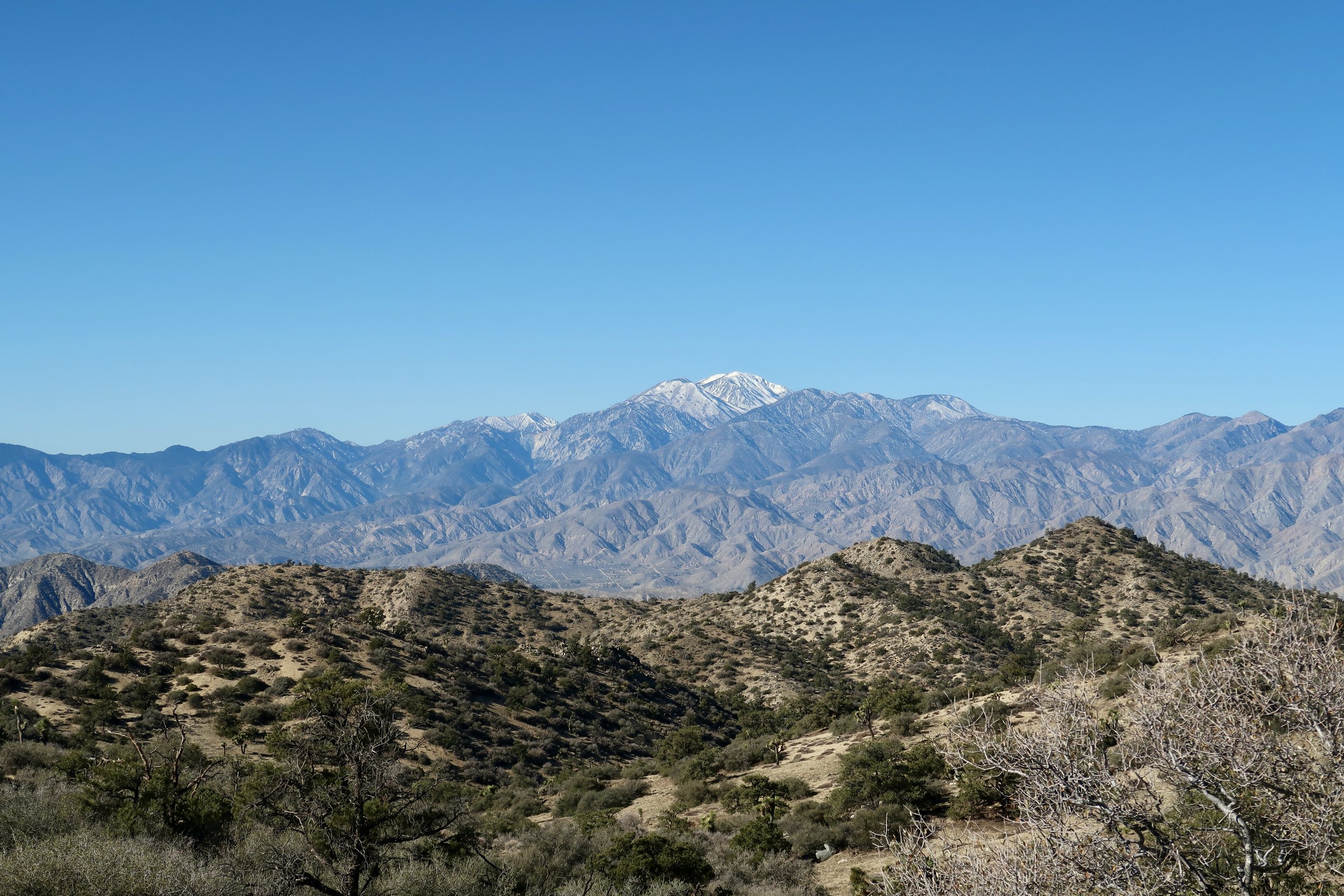
view of mount san gorgonio from the hi-view ridge
hi-view trail
located near the black rock campground, the trailhead to the 1.4 mile hi-view loop is down a bumpy dirt road through joshua trees. the trail climbs up a ridge to stunning views of mount san gorgonio. we did this one on a christmas morning and the ridge was extremely windy. but the views of the snowy mountains were well worth it! if you come in winter, be sure to pack layers. you’ll be grateful for it!

wildflower super bloom at the bajada nature trail
bajada nature trail
if you’re into desert flora, this is the stop for you! though not really hidden, this 0.3 mile bajada nature trail is at the cottonwood entrance of the park, so much less visited than other areas. the trail is full of interpretive signs about the diverse plantlife in the colorado desert section of the park. it’s also here where you’re much more likely to see wildflowers. were were fortunate enough to live in the area during the last major wildflower superbloom and the bajada nature trail was covered in lupine, chia, and more. it was a spectacular site to behold!
ryan ranch
this 1.1 mile out and back trail is a good one for kiddos who love to explore. along the trail there are great rocks for climbing, but it’s the historic adobe - or, ryan ranch - that’s the big reward. built in 1896, it’s fun to imagine what the 6-room adobe once looked like. and it’s a great spot for photos! you’ll also find a lot more historic remnants scattered through the area. and did i mention scrambling opportunities?
view of a snow dusted mount san gorgonio from the peak of panorama loop
panorama loop
this was our most recent christmas hike and it’s a workout with a reward! after a long, sandy trudge, followed by a steep climb, the views of both mount san gorgonio and the san jacintos are a real treat. the panorama loop is a 6.6 mile lollipop and is located near the black rock campground. if you are up for it, you could do both panorama and hi-view on the same day as the trailheads are quite close to one another - though not as a single, connected hike.

kiddo looking down from atop eureka peak
eureka peak
this peak is mostly traversed via a rigorous 10-mile hike, but it can be driven to, as well! the road is certainly off the beaten path - a very bumpy, windy dirt road that will take you through the most dense stands of joshua trees i’ve ever seen. honestly, the density of the joshua trees alone is worth this trek. but, the views from eureka peak are also pretty darn spectacular. be sure to download the map in advance for this one. it’s quite easy to get turned around and there’s no signage to ensure you’re headed the right direction.
maze loop
this 4.9 mile loop takes you through canyons and high rock walls that make it feel like you’re inside a maze of boulders. it’s a bit of a wonderland, and you’ll definitely want to make sure you download the map in advance. there are several areas where the trail seems to disappear, and it’s easy to wander off track. the maze loop trail is mostly flat but there are some rocky sections, as well as some very sandy sections.

kiddo hiking the mastodon peak loop in joshua tree
mastodon peak
mastodon peak definitely isn’t a secret, but it’s another one that’s over in the cottonwood section of the park and less visited than say… skull rock. but if you are in the area, it’s definitely the one to do! after recently camping in joshua tree at the cottonwood campground, this is actually our new favorite joshua tree hike! at just over 2.5 miles, this loop also includes an additional short scramble up to the peak. if you’re lucky, you may get to see salton sea from the summit! there’s also mastodon mine with some interpretive information about the history of mining in joshua tree. this hike does include some stairs, as well as some rocky sections with loose gravel.
favorite hot spots in joshua tree national park

the chollas at sunset
cholla cactus garden
the cholla garden is my top spot. there’s nowhere else i’d rather be. i call the teddy bear cholla my best friends and jokingly send my dear (human) friend a photo of me with my “friends” every time i visit. (i even have a cholla on my porch!) at the cholla garden there is a short boardwalk trail that wends it’s way through hundreds of these pokey wonders. this absolute gem is located in the colorado desert portion of the park which means no joshua trees, but so. many. cholla. plus smoke trees! it’s definitely a different ecosystem and worth traveling to. and while you’re down there, continue on to the cottonwood area of the park to check out the bajada nature trail and mastodon peak!
skull rock nature trail
skull rock is definitely one of the most popular spots in the park. most people park on the side of the road to take a quick picture with the skull, but only some realize there is a full 1.7 mile loop that brings different views. we first did this trail while camping at jumbo rocks and hardly recognized we were at skull rock until we were literally right on top of it. if you’re staying at the campsite this is a must-do!
arch rock
another popular spot, arch rock trail is fun because you’re able to see a lot of interesting geologic features. the arch itself is not particularly large - and definitely requires scrambling up sharp boulders - but the entire 1.2 mile lollipop loop brings a feast for the eyes. the trail head can be accessed from the twin tanks parking lot.
i’d love to know what your must-see spots are at joshua tree - especially the hidden gems! if we haven’t seen it already, we’re sure to check it out on our next visit! in the meantime, i hope this list gives you some ideas for ways to explore this national wonder beyond the amazing, well-known (and well-loved) hot spots. go out wild and enjoy some hidden gems at joshua tree national park!
pin this post for later!

favorite outdoor activities in tucson, az; things to do in tucson with kids
outdoor fun in tucson

saguaros and mountains of tucson, az
we traveled to tucson for one reason: saguaro national park. but what we found was an incredible city, brimming with activities for any kind of traveler. we ended up spending a couple extra days outside of the national park to explore some of the other outdoor attractions and were so glad we did. the natural beauty of arizona is undeniable, so we prioritized outdoor activities in tucson. here are a few of the family-friendly activities in tucson that we enjoyed!
raptor free flight at arizona-sonora desert museum
the arizona-sonora desert museum came highly recommended by several fellow travelers - specifically, the raptor free flight. the desert museum is a combined zoo and botanic garden, along with an aquarium (you can even pet stingrays!), history museum and art gallery. the grounds are quite large, so expect a lot of walking. (i cannot speak to accessibility of the entire experience, but paths throughout are well-paved with some meandering and elevation changes.) in addition to the raptors, we thoroughly enjoyed the javelinas and the cactus garden.
onto the birds! the raptor free flight is a sort of recess time for native sonoran birds of prey. the birds are completely untethered and are free to stretch their wings. the program is very educational and extremely entertaining! and when i tell you these birds get close, I mean they get CLOSE. they literally graze guests as they fly back and forth over guests. at one point, kiddo threw himself on the ground because one of the birds came right at my head! obviously these birds have razor-sharp senses and will not actually hit any guests, but it’s worth noting they get extremely close. (sweating emoji here - lol!)
it’s recommended you arrive at least 20 minutes before the start of the show, but i’d encourage getting to the desert museum at least 30 minutes in advance. it takes some time to get to the flying area and you’ll find plenty of other eager guests waiting in line! while the raptor show was definitely a highlight of entire trip, the rest of the desert museum is fabulous. it’s worth planning for a couple hours post-show to explore all the various attractions and learn about the sonoran desert along the way. this is definitely a memorable experience for kids in tucson!

a crested caracara in its sonoran habitat
sweetwater preserve
the sweetwater preserve is nearly 900 acres of incredible desert wildness in west tucson. there are over 15 miles of trails to explore for hikers and equestrians. the area is also very popular for mountain biking and includes trails for beginner and intermediate riders. trails range from 0.4 to 2.6 miles and can be combined any which way to create the distance that works best for you.
from the trailhead, the black rock loop trail is 4.6 miles and takes you through some incredible saguaro stands. for a more challenging trek, try the 7.1 mile saguaro vista, black rock, homestead and oxbow trail. and for a shorter hike try the saguaro vista, lost arrow, spine and wildflower ridge loop, which is 2.5 miles.
tucson botanical gardens
the tucson botanical gardens are a great place to explore and feature a butterfly pavilion that allows guests to interact with the butterflies! there are more than a dozen gardens to pique the interests of young and old, alike, including a native american crops garden, a children’s garden, a bird garden, and more. there’s also a desert tortoise that lives on the grounds! kiddo especially loved the zen garden, which was both a great sensory break and sensory engaging for kiddos who enjoy those features. and though not native, i always appreciate the rose and iris gardens.
the gardens also host a number of fantastic art exhibits and events. we explored the galleries and also enjoyed the festival of illumination, a holiday lights show.

kiddo hikes a trail in saguaro national park
saguaro national park
this one is obvious for any outdoors lover! check out this blog post which includes our itineraries for 2 days in saguaro national park and 1 day in saguaro national park. it’s worth noting the park has east and west sides, which are completely disconnected and about an hour’s drive apart. you could certainly visit both parks in a single day, but i’d recommend one day for each side so you can really enjoy and explore the unique ecosystems.
tucson is a very family friendly destination full of cultural and outdoor activities for all ages. we highly recommend a visit and hope this list gives you some great ideas to go out wild and explore the beauty of tucson’s sonoran desert.
pin this post for later!