search posts

favorite itinerary: 2 days in saguaro national park; 1 day in saguaro national park
one and two day itineraries for saguaro national park

kiddo hikes a trail in saguaro national park
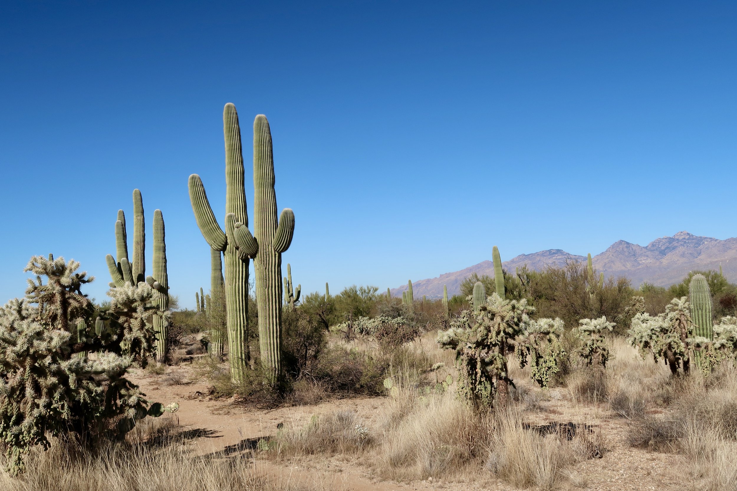
we all know i love a desert park and saguaro national park did not disappoint! this park is unusual in that it has two different sides that are completely separated by the city of tucson, az - though they’re a much shorter drive apart than the two sides of pinnacles national park!
both sides of the park have scenic drives that provide lots of options for exploration and enjoyment. the tucson mountain district, or west saguaro, is the most popular because it has a higher density of saguaros. the rincon mountain district, or east saguaro, on the other hand, is more mountainous - but still boasts plenty saguaros! both have a variety of longer hikes (over 5 miles) and shorter hikes (under 2 miles), but limited options for those medium distance hikes between 2 and 5 miles.

view of west saguaro national park with mountains in the distance
the land presently known as saguaro national park has been the homeland of indigenous peoples since time immemorial. tribal nations who have inhabited this area include Zuni, Hopi, Yaqui, Akimel O'odham, Tahono O’odham, and others.
the Tahono O’odham Nation shares: “on countless occasions, the U.S. border patrol has detained and deported members of the Tohono O’odham Nation who were simply traveling through their own traditional lands, practicing migratory traditions essential to their religion, economy and culture. similarly, on many occasions U.S. customs have prevented Tohono O’odham from transporting raw materials and goods essential for their spirituality, economy and traditional culture. border officials are also reported to have confiscated cultural and religious items, such as feathers of common birds, pine leaves or sweet grass.
the division of O’odham lands has resulted in an artificial division of O’odham society. O’odham bands are now broken up into 4 federally recognized tribes: the Tohono O’odham Nation, the Gila River Indian Community, the Ak-Chin Indian Community and the Salt River (Pima Maricopa) Indian community. each band is now politically and geographically distinct and separate.”

view from cactus wren trail in west saguaro national park
you could easily visit both sides over a weekend in saguaro national park. we like to take our time in parks, where possible, so we did two days in saguaro national park, one (shorter) day for each side. however, because the parks aren’t too far apart (a 1 hour drive), you could certainly do one day in saguaro national park and get to both sides. here’s what we recommend seeing and doing on your visit!
day 1 in saguaro national park: west/tucson mountain district
hike the scenic/packrat/passey loop: this 1.7 mile hike is off-the-beaten path disconnected (by road) to the rest of west saguaro. however, we found it to be the perfect intro to the park as a low-key loop full of diverse desert flora - including saguaros, of course! you can also shorten or lengthen this hike by taking different variations of the three trails.

kiddo hikes through the cholla on the scenic/passey/packrat loop trail
2. head into the park and stop at the red hills visitor center for maps and information. make sure to ask about the hike for health challenge. if you hike 3 miles, you get a special pin! this challenge can also be done at five other national park sites, though details vary.
3. start the bajada loop drive. this 6 mile scenic drive offers pullouts, hikes and picnic spots. be advised that the loop is unpaved and while some of the loop is two-way, not all of it is. it’s best to do the full loop counter clockwise so you don’t end up having to backtrack to get to the following stops.
4. hike the valley view and wild dog trails. this 2.6 miles out and back combo starts from the same trailhead and will likely be your first stop on the bajada loop. you could also do the 0.6 mile valley view overlook trail and then continue on the bajada loop to signal hill. you can do the 1.9 mile out and back wild dog trail from signal hill. because there are several other trails at signal hill, i recommend knocking out wild dog while doing valley view. be advised, the parking at this trailhead is extremely limited. another reason to combine trails and make this your first stop on the loop.
5. continue on the bajada loop to the signal hill picnic area. enjoy lunch with a view before setting off to view the signal hill petroglyphs. the petroglyphs, which are 0.5 mile hike from the picnic area, were created by the hohokam people between 500 and 1500 years ago. the petroglyphs are a *do not miss! from here, you have the option to connect to manville, cactus wren and encinas trails. we did the cactus wren trail, and really enjoyed the views. a great way to wrap up one day in west saguaro national park!

petroglyphs at signal hill
day 2 in saguaro national park: east/rincon mountain district
1. start off the day at rincon mountain visitor center if you need any additional maps or updated information specific to this side of the park.
2. set off on the cactus forest scenic loop. this 8 mile scenic drive is paved and has a number of scenic pullouts, in addition to trail access for hiking, biking and horseback riding.
3. though we stopped at all the pullouts along the way, our first excursion was the mica view/cholla/cactus forest loop. this 3.7 mile trail is a great option for exploring deeper into the park beyond the scenic drive. you can also shorten to 1.9 miles via the mica view/cactus forest loop. or, if you are able to do a day hike, i’d highly recommend the 10 mile cactus forest trail. it’s less traversed than the shorter trails and takes you through diverse areas of the park. any section of the cactus forest trail is a *do not miss!
landscape from the mica view trail
4. continue on the scenic drive to the desert ecology trail. this 0.3 mile accessible trail was one of our favorites! the interpretive signs are full of great information about how the flora and fauna work together to create a thriving desert ecosystem. this is a *do not miss learning opportunity!
5. continue around the loop, stopping at the various viewing pullouts and choosing one for a picnic with a view. we especially loved the javelina rocks stop, which offers the opportunity to get out and explore. just a bit further is the javelina picnic area. we stopped here to complete the junior ranger book, stretch our legs, and use the restroom. from here, wrap up the loop and return to the visitor as needed for junior ranger badges or hike for health pins. congrats on completing your visit to another beautiful national park!
one day itinerary: 1 day in saguaro national park
if you only have one day to explore saguaro national park, i’d still recommend traveling to both sides of the park. most blogs will tell you to stick to the west side but the east side was my favorite and brings a little more of an off-the-beaten-path experience. here are the top spots to include for one day in saguaro national park.
start at west saguaro national park
red hills visitor center
bajada loop drive (counterclockwise)
signal hill petroglyphs
drive to east saguaro national park
cactus forest scenic loop drive
mica view/cactus forest loop trail
desert ecology trail
rincon mountain visitor center, if needed

trail at the javelina rocks pullout in east saguaro national park
i hope this saguaro national park itinerary helps you plan a successful trip. may you enjoy another opportunity to go opportunity to go out wild!
pin this post for later!

favorite itinerary: 2 days in death valley national park
two days in death valley national park

death valley national park is an otherworldly fever dream! i’m a huge fan of desert ecosystems and this one just blew me away! we spent 2 full days exploring death valley and enjoyed every second of it. you can see a lot spending a weekend in death valley national park. we had actually planned on a third day, but car trouble bested us. and yet, 2 days in death valley ended up being enough! three days in death valley would also provide more flexibility to see some of the farther out sites.
the land presently called death valley is the homeland of the timbisha shoshone, who were placed in the region by creator appü. for the timbisha shoshone, death valley is tüpippüh and the land of tümpisa, or “red ochre”. miners arrived in the 1800s and the timbisha shoshone were pushed out of their homeland and “relocated” multiple times, including forced removal by the National Park Service. they have continued to live in the area and in the year 2000, 7700 acres of their homeland was restored via the timbisha shoshone homeland act. though there are hundreds of tribal members, there are currently several dozen that live year round within the park’s boundaries.
pauline esteves, a tribal elder shares, “the spirit of timbisha has received many travelers from other lands, and all of mother earth’s belongings; the home of the timbisha shoshone newe (peoples), has been used as a commodity of sorts. timbisha is not a “valley of death” – it is a valley of the red ochre. red ochre is used spiritually by the newe with its “healing power.” not of death but for life. waters from the mountains to the east and west flow underground into this valley. overflows of nearby springs once formed streams of surface water by its own course, bringing life.”
one thing i found especially surprising about death valley national park is the way visitors are invited right into the landscape. it’s nothing i’ve experienced in any other national park before (for good reasons). many places in the park don’t even have a trail and you are allowed to simply wander. these include badwater basin, devil’s golf course, nature bridge, mesquite flat sand dunes, artists palette, and more! do be sure to read all signage before deviating away from clearly designated areas.
here’s our death valley 2 day itinerary. (of note, the park experienced devastating floods in summer 2022. roads were destroyed, along with exhibits and more. be sure to check the death valley national park website before your visit to make note of closures and re-openings.)
day 1 in death valley national park
1. stop at the furnace creek visitor center for maps and information.
2. visit badwater basin: this 200 square mile salt flat is the lowest point in north america at more than 280 feet below sea level. we caught a morning ranger program here that was spectacular. note the endemic snails that live in the salty spring that bubbles up at the flats. this goes on the *do not miss list. also of note, this location is one of the most wheelchair accessible in the park. though the flats themselves are not paved, some wheelchairs would likely do fine. we did see tire tracks on the flats.

view from the salt flats at bad water basin
3. hike natural bridge: over many years, flash floods carved out this canyon and the natural bridge that spans it. there is a bumpy dirt road to a parking area, and the bridge is a 0.5 mile hike from there. there is no official path, but following the canyon will get you there. you can also explore beyond the bridge. there is a fascinating formation that appears to be a waterfall during floods. it’s reminiscent of a cathedral.

a 35 foot natural bridge spans a canyon in death valley national park
4. visit devils golf course: add this to the list of places that make death valley feel like another planet. the devils golf course is a massive “sea” of rock salt. erosion has left it pitted, sharp and rocky. it felt especially odd to just step onto the golf course, but signage allows it with warnings to be cautious about the sharp formations. they are very tricky to walk on and if you slip there’s nothing safe to grab ahold of or land on. while this is another spot that requires a drive on dirt road, it’s well worth the stop!

kiddo plays on the devils golf course salt rocks
5. explore artists drive: this is another one that goes on the *do not miss list for death valley national park! the colors are truly phenomenal - kiddo said it looked like ice cream and i have to agree. it’s a pleasant drive and there are several places to pull over. the main attraction is artists palette. visitors are able to walk directly onto the formation. there is an informal trail and lots of freedom to explore.

a view of artists palette showing the pinks, purples, greens and browns of the land
6. wander the mesquite flat sand dunes: the dune fields are a spectacular place to visit at sunrise or sunset. we went for golden hour and sunset and it didn’t disappoint! there is nowhere to rent them, but visitors are welcome to bring their own sleds or boards to use on the dunes. visitors also have the option to do a 1-mile hike out to the tallest dune (two miles round trip). there is no trail. we just wandered to our own private dune and hung out to watch the colors change. a perfect way to end your first day in death valley national park!

mesquite flat sand dunes
day 2 in death valley national park
hike golden canyon and gower gulch: many know this as the star wars hike. though there are several areas of the park where filming occurred, golden canyon is the most readily recognizable. we enjoyed this 4.6 mile loop - the views are spectacular! if you have time, add on the red cathedral trail (1 mile total) and/or the badlands loop (2.7 miles). we had hoped to do the badlands loop from zabriskie point but didn’t have time. you can still view the badlands from zabriskie point (below).

views of death valley hills from golden canyon
2. check out the park from above at dantes view: at 5575 feet, visitors are able to see the valley below, including bad water basin, devils gold course and more. the park recommends visiting at sunrise, sunset or dark, all of which sound magical. we visited smack in the middle of the day and it was still spectacular! be advised, the temperature is much cooler up here compared with the valley floor - likely a huge relief during scorching hot days!

view of death valley hills from atop dante’s view
3. drive through twenty mule team canyon: this 2.5 mile canyon is a short drive that feels a bit like driving through the death valley badlands. it only takes a few minutes to travel through and is between dantes view and zabriskie point. so, worth a quick drive through if you’re going to the other two anyways!
4. enjoy golden hour at zabriskie point: this was my favorite spot of all the special places we visited during our weekend in death valley national park. if you get there early enough, do the badlands hike and then stroll up zabriskie point for golden hour and sunset. it is truly spectacular! i loved it so much i planned to do it the next evening, as well, but you know… car trouble. anyway, it’s a fantastic spot and is a *do not miss! the most special way to end 2 days in death valley national park!

if you have more time
harmony borax works: we hadn’t planned to visit this site but had some extra time and stopped by. it was so interesting! it’s a quick stop and a great place to learn about a bit of the park’s history and what ultimately led to the park’s popularity. it’s also where the evening ranger programs take place, so worth seeing in daylight, too.
mosaic canyon: this had been on our itinerary and got cut when car trouble arose. we would have loved to see this geological wonder!
wildrose charcoal kilns: these kilns look to be another incredible historic feature of the park. we weren’t able to get out to this area, but if you’re already passing through, seems like these kilns would be a wonderful thing to see.
ubehebe crater: this was closed due to flooding on our visit but we hope to see it someday!
devil’s hole/ash meadow national wildlife refuge: we stopped here on our way out of death valley, and it was well worth it! we wanted to see the devil’s hole pupfish, which are one of the rarest fish in the world. we also stopped at the point of rocks site where we saw pupfish up close and bighorn sheep from afar!

the platform path at point of rocks site in ash meadows national wildlife refuge
death valley national park is definitely one of our top national parks we’ve visited so far. i hope this 2 day itinerary is helpful and that you enjoy your visit!
pin this post for later!

favorite itinerary: 3 california national parks in 10 days; pinnacles, yosemite, lassen volcanic national parks
ten day itinerary for pinnacles, lassen volcanic and yosemite national parks

manzanita lake at lassen volcanic national park
we’re fortunate in california to have nine national parks (not to mention all the other national park sites!). and they’re pretty evenly disbursed, so just about anywhere you travel in california, you’re bound to not be too far from a national park. so far we’ve visited two-thirds of the state’s parks and have a lot of favorites from each. here’s an itinerary for three california national parks in 10 days: pinnacles, yosemite and lassen volcanic national parks. with this itinerary you’ll spend two days in pinnacles national park, two days in yosemite national park and two days in lassen volcanic national park. you’ll see these recommendations are hike-heavy. that’s because that’s what we feel is one of the best ways to see these national wonders. however, be sure to do your research as each park has it’s own museums and other attractions that are worthy stops if you have time. further, the vast majority of of national park hikes are inaccessible for a variety of disabilities. if you have questions about accessible options, please reach out and i can connect you with some resources.
10-day itinerary for northern california national parks
day 1: fly into san francisco or sacramento; drive to pinnacles national park
pinnacles national park is about 2.5 hours from san francisco and 3 hours from sacramento.
pinnacles national park is the homeland of the amah mutsun and the chalon people. both tribes continue to have relationships with the land. for the amah mutsun, condors are significant as they escort the dead to the next world.
there are extremely limited transportation options in the park and you should plan to drive throughout your visit.
pinnacles national park has two sides that are about 1.5 apart by car. i recommend spending one day on each side. despite pinnacles being a small park, it would be really challenging to do both sides in a day due to the drive between.
you should aim to see three highlights of pinnacles national park: pinnacles, talus caves, california condors. this itinerary gives you the opportunity to see all!
i recommend staying in the campground in east pinnacles. there is no other campground on either side of the park.
if you arrive and set up camp before dark, hike the bench trail from the campground. it’s a lovely walk and you can spot different animals coming out at dusk.
day 2: east pinnacles national park
visit the east pinnacles book store/visitor center. it’s small, but somehow we spent more money here than any other national park - lol!
at time of this writing bear gulch nature center is closed indefinitely. if it’s open, be sure to visit!
hike moses spring to rim trail loop. this includes traveling through bear gulch cave! read more about the pinnacles caves and their statuses here. this loop is 2.2 miles and is a *do not miss! (all trail information is here.)
hike condor gulch trail. the full trail is 3.4 miles out and back, but you can also hike 1 mile to the overlook and back for a less strenuous hike.
if you have time and it’s an option for you, hike the high peaks trail. this is where we saw the most california condors, one of the rarest birds in the world. you can connect to it from the rim trail if you are already hiking the moses spring to rim trail loop. tips on spotting condors.

day 3: west pinnacles national park
drive to west pinnacles. this drive is approximately 90 minutes from east pinnacles.
hike the juniper canyon loop. this hike is 4.3 miles and has some steep climbs, but you’re rewarded with incredible views of the pinnacles. you could hike up to the view just before the switchbacks to tunnel trail and back down for a 2.5 mile out and back hike. seeing this view is a *do not miss!
hike the balconies cave-cliffs loop. this loop is 2.4 miles and gives you another opportunity to explore the talus caves. some parts of this trail are not particularly well-marked and we passed multiple hikers who turned around to try the loop in the opposite direction. also be advised that balconies cave is quite different from the bear gulch cave as it is smaller, doesn’t have an established path and requires more climbing.
return to east pinnacles campground.

juniper canyon loop in pinnacles national park
day 4: drive to yosemite national park
make your way to yosemite national park. the drive between east pinnacles national park and the yosemite valley is about 4 hours.
yosemite national park is the homeland of the southern sierra miwuk and paiute. the southern sierra miwuk have partnered with yosemite to restore the wahhoga village. they are also currently raising funds for oak fire relief efforts. donate here.
if you are visiting yosemite in winter, check out this list of our favorite activities for winter in yosemite.
there are so many wonderful places to stay in and near yosemite national park, including 13 campgrounds. we camped outside the south end of the park. we’d love to camp in the park on our next visit!
go to the yosemite valley visitor center to get maps and a layout of the valley and beyond.
go to tunnel view to watch the sunset. get there early for parking. we went in winter a bit before golden hour and the lot never filled. however, it’s likely much busier during peak seasons.

tunnel view at sunset in yosemite national park
day 5: yosemite national park
hike mirror lake. i recommend the two mile out and back trail, especially if you’re planning to go to tuolumne meadow and lembert dome. we did this in winter and it was gorgeous! there is also the option to hike the 5 mile loop around the lake.
hike cook’s meadow. this 1 mile loop offers gorgeous views of yosemite’s top sites, including yosemite falls and half dome.
hike yosemite falls. you have a couple options. hike the lower fall trail, which is a 1 mile loop. or the columbia rock trail, which is 2 miles and offer views of the upper fall.
drive to tuolumne meadow. this is a 90 minute drive from the valley, but if weather permits, it’s worth seeing! if you have more in you, hike lembert dome for a view of the meadows. it’s 3.4 miles and offers unique scenery.
day 6: yosemite national park
drive to glacier point for sunrise (open to cars spring-fall; check conditions before you go as recent road improvements have led to closures).
hike taft point and/or sentinel dome. taft point is 2.2 miles and offers some of the best views in the park. sentinel dome is right near taft point. though it’s shorter at 1.8 miles, the elevation gain is twice that of taft point. (again, check for road closures for both of these hikes.)
hike vernal fall. though this hike is a tough climb, it’s one of yosemite’s most epic. at 3 miles, this section of the mist trail is a treat! be prepared for slippery rocks as it’s constantly wet. you also have the option to continue up the mist trail to the top of nevada fall (7.2 miles total).
hike bridalveil fall. if you’re still up for more incredible waterfall hikes, this is a fantastic one to close out your visit to yosemite. this is actually my favorite of the yosemite attractions we visited. it’s 0.5 mile and is open year-round; we visited in winter.

yosemite national park in winter
day 7: drive to lassen volcanic national park
the drive between yosemite valley and lassen volcanic national park is about 6.5 hours. stop in sacramento or mt. shasta for a break along the way!
lassen volcanic national park was a seasonal resource gathering place for the yana, yahi and atsugewi peoples. the park’s first female naturalist was selena lamar, an atsugewi tribal member, who provided cultural demonstrations.
lassen is best visited in summer. this park is prone to long seasonal road closures. we visited in early july and there was still snow and some closures!
you’ll want to be sure to see the hydrothermal features, as well as all four volcano types that exist in the park.
there are seven campgrounds in lassen, with options for all kinds of campers. we ended up camping outside the park because there was no availability at the time we visited. be sure to book early if you’re planning to stay in the park!
day 8: lassen volcanic national park
start at the kohm yah-mah-nee visitor center. (if you are in an area of the park where it is closer to get to cinder cone first, start there and follow the rest of the itinerary, stopping at the visitor center last.)
hike cinder cone. there’s no getting around the fact that cinder cone is far and out of the way of the rest of the park. however, this was by far our favorite hike in the park. this is a *do not miss! it’s so cool! you are literally hiking a volcano and have the option to go down inside the cone! the hike is 4 miles total and is strenuous. be prepared to be exposed and for a tough, slippery climb. for a shorter (though still strenuous climb), go up and back down the front of the cone. we took the longer route and the views from the back are unbeatable.
hike bumpass hell. this is another *do not miss, featuring the park’s hydrothermal features at their best. the trail is 3 miles of gorgeous views the entire way.
stop at sulphur works on your way out of the park. this is a quick stop that allows you to get up close and personal with mud pots, one of the park’s hydrothermal features. this view is accessible.

view of lassen peak from the top of cinder cone
day 9: lassen volcanic national park
hike kings creek falls, a 2.3 mile loop to 30 ft. falls. if this hike is not for you, i highly recommend that you stop for a rest in kings creek meadow, which is roadside. it is absolutely picturesque and can be viewed right from your vehicle.
visit devastated area interpretive trail. this 0.5 mile accessible trail is well worth the visit. it provides a great overview of the history and geology of the park.
spend an afternoon at manzanita lake. this lake is gorgeous and the perfect way to end a whirlwind adventure through northern california national parks. hike the 1.7 mile loop around the lake to get all the views. then rent a kayak and explore from the water. bring a picnic along, too!
return to camp.

bumpass hell in lassen volcanic national park
day 10: fly out of san francisco or sacramento
drive back down to the airport and pat yourself on the back for an adventure well done!
the drive from lassen to san francisco is about 4.5 hours and to sacramento about 3 hours.
bonus: 14-day california national parks itinerary
if you have a full two weeks you’ll have more wiggle room for travel days and can add redwood national and state parks. in this case i’d do the reverse - fly into san francisco and head to redwood national park first. then hit lassen volcanic national park, followed by yosemite national park. and finally, stop in pinnacles national park before heading back home.

hiking in redwood national park
save this pin for a 10-day norcal national parks itinerary

favorite things to do in yosemite in winter
winter hikes and sites in yosemite national park

this post contains affiliate links. there is no cost to you to engage with these links and it helps to offset the cost of my time to provide these resources.
visiting yosemite in winter is an absolute dream. our first trip to yosemite national park was in the middle of winter and the snow and ice added to the overwhelming magic. though some roads, trails and areas of the park close during wintry months, there’s still plenty to do in yosemite in winter. here are our favorite winter activities to add to your yosemite itinerary, including winter hikes.
favorite winter hikes in yosemite
mirror lake

2 miles out and back or 5 miles around the lake
while mirror lake does take some extra effort to get to in winter (due to closure of parking areas), we found the trip to be well worth it!
tip - be sure to pack micro spikes (or these for kids) if you’re visiting mirror lake in winter. much of the path is an ice rink unless you’re treading on freshly fallen snow.
lower yosemite fall

1 mile loop
yosemite falls are an iconic must-see landmark in yosemite national park. while the upper fall trail remains open, not all of us are up for a 7 mile, difficult trek in the snow. the lower fall trail is a gentle loop with a whole lot of magic. this is a do not miss!
favorite no-hike winter activities in yosemite
tunnel view

tunnel view is a must-visit for any yosemite itinerary! while tunnel view is stunning at any time, we went to tunnel view at sunset. sunset was gorgeous, but it was blue hour at tunnel view that stole my heart.
swinging bridge

the swinging bridge picnic area (not to be confused with the wawona swinging bridge) provides a gorgeous waterfall view and a place to just relax. we spent some time strolling and playing in the snow. there’s an option to follow intersecting trails or just enjoy the picnic area. (note the swinging bridge is not actually a swinging bridge!)
sledding

snow means sledding! sledding in yosemite national park is its own special kind of fun. we went to the crane flat campground, where the snow was deep enough to cover the bathroomw and we could sled right over picnic tables without even realizing it!

i hope this list of our favorite things to do in yosemite national park in winter inspires a cold weather trip to this special place.